Les Herbiers geodata
Les Herbiers (Pays de la Loire) is a populated place; located in France in Europe/Paris (GMT+2) time zone. With population of 15,664 people, there are 614 cities with bigger population in this country. Compared to other cities in France, 56.5% of cities are located further ↑North; 88.3% of cities are located further →East and 56.9% of cities have higher elevation than Les Herbiers. Note1
Administrative division(s):
- Level 1: Pays de la Loire
- Level 2: Département de la Vendée
- Level 3: Arrondissement de La Roche-sur-Yon
- Level 4: Les Herbiers


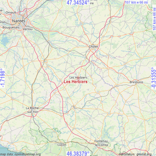
Les Herbiers GPS coordinates[2]
46° 52' 0.012" North, 1° 1' 0.012" West
| Map corner | latitude | longitude |
|---|---|---|
| Upper-left | 47.34524°, | -1.7198° |
| Center: | 46.86667°, | -1.01667° |
| Lower-right: | 46.38379°, | -0.31355° |
| Map W x H: | 106.9×106.9 km | = 66.4×66.4mi |
| max Lat: | 51.07786° ⇑56.5% North |
| Les Herbiers: | 46.86667° |
| min Lat: | ⇓43.5% South 41.3874° |
| min Long | Les Herbiers | max Long |
| -5.08615° | -1.01667° | 9.52242° |
| W 11.7%⇐ | ⇒88.3% E |
Elevation
Elevation of Les Herbiers is 111 m = 364 ft, and this is 82.7 m = 271 ft below average elevation for this country.
| Max E: |
2333 m = 7654 ft | 56.9% |
| Avg. | 193.7 m = 635 ft | |
| Les Herbiers | 111 m = 364 ft | |
Min E: |
-1 m = -3 ft | 43.1% |
See also: France elevation on elevation.city.
Geographical zone
Les Herbiers is located in North temperate zone (between Tropic of Cancer and the Arctic Circle). Distance of this North polar circle is 2190.1 km =1360.9 mi to North.| Distance of | km | miles | from Les Herbiers |
|---|---|---|---|
| North Pole | 4796 | 2980.1 | to North |
| Arctic Circle | 2190.1 | 1360.9 | to North |
| Tropic Cancer | 2605.2 | 1618.8 | to South |
| Equator | 5211.1 | 3238 | to South |


Nearby cities:
15 places around Les Herbiers: (largest is in red/bold)
• Bazoges-en-Paillers
10.2 km =6.3 mi,  296°
296°
• Beaurepaire
7.3 km =4.5 mi,  310°
310°
• Chambretaud
7.3 km =4.5 mi,  33°
33°
• La Gaubretière
9 km =5.6 mi,  337°
337°
• La Verrie
10.6 km =6.6 mi,  8°
8°
• Le Boupère
10.4 km =6.5 mi,  138°
138°
• Les Epesses
9.1 km =5.7 mi,  78°
78°
• Mesnard-la-Barotière
6.3 km =3.9 mi,  261°
261°
• Mouchamps
10.1 km =6.3 mi,  199°
199°
• Rochetrejoux
8.7 km =5.4 mi,  169°
169°
• Saint-Malô-du-Bois
11.6 km =7.2 mi,  50°
50°
• Saint-Mars-la-Réorthe
7 km =4.3 mi,  94°
94°
• Saint-Michel-Mont-Mercure
11 km =6.8 mi,  112°
112°
• Saint-Paul-en-Pareds
5.4 km =3.4 mi,  157°
157°
• Vendrennes
9.3 km =5.8 mi,  240°
240°
Sources, notices
• [Note1] Compared only with cities in France existing in our database
• [Src1] Map data: © OpenStreetMap contributors (CC-BY-SA)
• [Src2] Other city data from geonames.org with taken over terms of usage.
• [Src3] Geographical zone / Annual Mean Temperature by Robert A. Rohde @ Wikipedia
