Saint-Alexandre geodata
Saint-Alexandre (Occitanie) is a populated place; located in France in Europe/Paris (GMT+2) time zone. With population of 1,065 people, there are 8370 cities with bigger population in this country. Compared to other cities in France, 85.3% of cities are located further ↑North; 73% of cities are located further ←West and 53.1% of cities have higher elevation than Saint-Alexandre. Note1
Administrative division(s):
- Level 1: Occitanie
- Level 2: Gard
- Level 3: Arrondissement de Nîmes
- Level 4: Saint-Alexandre


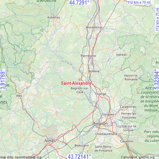
Saint-Alexandre GPS coordinates[2]
44° 13' 38.676" North, 4° 37' 14.916" East
| Map corner | latitude | longitude |
|---|---|---|
| Upper-left | 44.7291°, | 3.91769° |
| Center: | 44.22741°, | 4.62081° |
| Lower-right: | 43.72141°, | 5.32394° |
| Map W x H: | 112×112 km | = 69.6×69.6mi |
| max Lat: | 51.07786° ⇑85.3% North |
| Saint-Alexandre: | 44.22741° |
| min Lat: | ⇓14.7% South 41.3874° |
| min Long | Saint-Alexandre | max Long |
| -5.08615° | 4.62081° | 9.52242° |
| W 73%⇐ | ⇒27% E |
Elevation
Elevation of Saint-Alexandre is 122 m = 400 ft, and this is 71.7 m = 235 ft below average elevation for this country.
| Max E: |
2333 m = 7654 ft | 53.1% |
| Avg. | 193.7 m = 635 ft | |
| Saint-Alexandre | 122 m = 400 ft | |
Min E: |
-1 m = -3 ft | 46.9% |
See also: France elevation on elevation.city.
Geographical zone
Saint-Alexandre is located in North temperate zone (between Tropic of Cancer and the Arctic Circle). Distance of this Northern Tropic circle is 2311.7 km =1436.4 mi to South.| Distance of | km | miles | from Saint-Alexandre |
|---|---|---|---|
| North Pole | 5089.4 | 3162.4 | to North |
| Arctic Circle | 2483.5 | 1543.2 | to North |
| Tropic Cancer | 2311.7 | 1436.4 | to South |
| Equator | 4917.6 | 3055.7 | to South |


Nearby cities:
15 places around Saint-Alexandre: (largest is in red/bold)
• Bagnols-sur-Cèze
7.5 km =4.7 mi,  181°
181°
• Carsan
2.1 km =1.3 mi,  290°
290°
• Chusclan
10 km =6.2 mi,  151°
151°
• Lapalud
10.5 km =6.5 mi,  31°
31°
• Mondragon
7.4 km =4.6 mi,  80°
80°
• Mornas
9 km =5.6 mi,  108°
108°
• Pont-Saint-Esprit
3.7 km =2.3 mi, 34°
• Sabran
10.3 km =6.4 mi,  214°
214°
• Saint-Gervais
6 km =3.7 mi,  216°
216°
• Saint-Julien-de-Peyrolas
8.1 km =5 mi,  326°
326°
• Saint-Just-d'Ardèche
8.1 km =5 mi,  357°
357°
• Saint-Nazaire
3.2 km =2 mi, 175°
• Saint-Paulet-de-Caisson
4.1 km =2.5 mi, 333°
• Saint-Étienne-des-Sorts
8.2 km =5.1 mi,  124°
124°
• Vénéjan
4.3 km =2.7 mi,  141°
141°
Sources, notices
• [Note1] Compared only with cities in France existing in our database
• [Src1] Map data: © OpenStreetMap contributors (CC-BY-SA)
• [Src2] Other city data from geonames.org with taken over terms of usage.
• [Src3] Geographical zone / Annual Mean Temperature by Robert A. Rohde @ Wikipedia
