Avignon geodata
Avignon (Provence-Alpes-Côte d'Azur) is a seat of a second-order administrative division; located in France in Europe/Paris (GMT+2) time zone. With population of 89,769 people, there are 43 cities with bigger population in this country. Compared to other cities in France, 87.6% of cities are located further ↑North; 75.2% of cities are located further ←West and 89.5% of cities have higher elevation than Avignon. Note1
Administrative division(s):
- Level 1: Provence-Alpes-Côte d'Azur
- Level 2: Département du Vaucluse
- Level 3: Arrondissement d’Avignon
- Level 4: Avignon


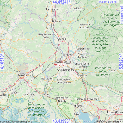
Avignon GPS coordinates[2]
43° 56' 54.024" North, 4° 48' 32.112" East
| Map corner | latitude | longitude |
|---|---|---|
| Upper-left | 44.45241°, | 4.10579° |
| Center: | 43.94834°, | 4.80892° |
| Lower-right: | 43.43996°, | 5.51204° |
| Map W x H: | 112.6×112.6 km | = 70×70mi |
| max Lat: | 51.07786° ⇑87.6% North |
| Avignon: | 43.94834° |
| min Lat: | ⇓12.4% South 41.3874° |
| min Long | Avignon | max Long |
| -5.08615° | 4.80892° | 9.52242° |
| W 75.2%⇐ | ⇒24.8% E |
Elevation
Elevation of Avignon is 31 m = 102 ft, and this is 162.7 m = 534 ft below average elevation for this country.
| Max E: |
2333 m = 7654 ft | 89.5% |
| Avg. | 193.7 m = 635 ft | |
| Avignon | 31 m = 102 ft | |
Min E: |
-1 m = -3 ft | 10.5% |
See also: Avignon elevation on elevation.city.
Geographical zone
Avignon is located in North temperate zone (between Tropic of Cancer and the Arctic Circle). Distance of this Northern Tropic circle is 2280.7 km =1417.2 mi to South.| Distance of | km | miles | from Avignon |
|---|---|---|---|
| North Pole | 5120.5 | 3181.7 | to North |
| Arctic Circle | 2514.6 | 1562.5 | to North |
| Tropic Cancer | 2280.7 | 1417.2 | to South |
| Equator | 4886.6 | 3036.4 | to South |


Nearby cities:
15 places around Avignon: (largest is in red/bold)
• Barbentane
7.3 km =4.5 mi,  222°
222°
• Châteaurenard
8.3 km =5.2 mi,  153°
153°
• Jonquerettes
9.9 km =6.2 mi,  91°
91°
• Le Pontet
4.3 km =2.7 mi,  70°
70°
• Les Angles
3.8 km =2.4 mi,  286°
286°
• Montfavet
5.4 km =3.4 mi,  107°
107°
• Morières-lès-Avignon
7.4 km =4.6 mi,  96°
96°
• Pujaut
6.7 km =4.2 mi,  336°
336°
• Rochefort-du-Gard
10 km =6.2 mi, 288°
• Rognonas
5.4 km =3.4 mi,  184°
184°
• Saint-Saturnin-lès-Avignon
9.4 km =5.8 mi, 85°
• Sauveterre
8.4 km =5.2 mi,  351°
351°
• Sorgues
8.6 km =5.3 mi,  37°
37°
• Vedène
8.3 km =5.2 mi, 67°
• Villeneuve-lès-Avignon
2.4 km =1.5 mi, 335°
Sources, notices
• [Note1] Compared only with cities in France existing in our database
• [Src1] Map data: © OpenStreetMap contributors (CC-BY-SA)
• [Src2] Other city data from geonames.org with taken over terms of usage.
• [Src3] Geographical zone / Annual Mean Temperature by Robert A. Rohde @ Wikipedia
