Montfavet geodata
Montfavet (Provence-Alpes-Côte d'Azur) is a section of populated place; located in France in Europe/Paris (GMT+2) time zone. With population of 14,000 people, there are 678 cities with bigger population in this country. Compared to other cities in France, 87.7% of cities are located further ↑North; 76.1% of cities are located further ←West and 88.3% of cities have higher elevation than Montfavet. Note1
Administrative division(s):
- Level 1: Provence-Alpes-Côte d'Azur
- Level 2: Département du Vaucluse
- Level 3: Arrondissement d’Avignon
- Level 4: Avignon


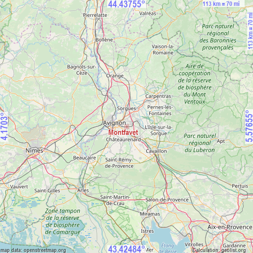
Montfavet GPS coordinates[2]
43° 56' 0.06" North, 4° 52' 24.312" East
| Map corner | latitude | longitude |
|---|---|---|
| Upper-left | 44.43755°, | 4.1703° |
| Center: | 43.93335°, | 4.87342° |
| Lower-right: | 43.42484°, | 5.57655° |
| Map W x H: | 112.6×112.6 km | = 70×70mi |
| max Lat: | 51.07786° ⇑87.7% North |
| Montfavet: | 43.93335° |
| min Lat: | ⇓12.3% South 41.3874° |
| min Long | Montfavet | max Long |
| -5.08615° | 4.87342° | 9.52242° |
| W 76.1%⇐ | ⇒23.9% E |
Elevation
Elevation of Montfavet is 34 m = 112 ft, and this is 159.7 m = 524 ft below average elevation for this country.
| Max E: |
2333 m = 7654 ft | 88.3% |
| Avg. | 193.7 m = 635 ft | |
| Montfavet | 34 m = 112 ft | |
Min E: |
-1 m = -3 ft | 11.7% |
See also: France elevation on elevation.city.
Geographical zone
Montfavet is located in North temperate zone (between Tropic of Cancer and the Arctic Circle). Distance of this Northern Tropic circle is 2279 km =1416.1 mi to South.| Distance of | km | miles | from Montfavet |
|---|---|---|---|
| North Pole | 5122.1 | 3182.7 | to North |
| Arctic Circle | 2516.2 | 1563.5 | to North |
| Tropic Cancer | 2279 | 1416.1 | to South |
| Equator | 4884.9 | 3035.3 | to South |


Nearby cities:
15 places around Montfavet: (largest is in red/bold)
• Avignon
5.4 km =3.4 mi,  287°
287°
• Caumont-sur-Durance
7.4 km =4.6 mi,  126°
126°
• Châteauneuf-de-Gadagne
5.7 km =3.5 mi,  97°
97°
• Châteaurenard
5.9 km =3.7 mi,  194°
194°
• Entraigues-sur-la-Sorgue
8.9 km =5.5 mi,  28°
28°
• Jonquerettes
5 km =3.1 mi,  72°
72°
• Le Pontet
3.3 km =2.1 mi,  340°
340°
• Les Angles
9.2 km =5.7 mi, 287°
• Morières-lès-Avignon
2.3 km =1.4 mi, 70°
• Noves
6.6 km =4.1 mi,  159°
159°
• Rognonas
6.7 km =4.2 mi,  236°
236°
• Saint-Saturnin-lès-Avignon
4.8 km =3 mi,  59°
59°
• Sorgues
8.5 km =5.3 mi,  0°
0°
• Vedène
5.5 km =3.4 mi, 26°
• Villeneuve-lès-Avignon
7.3 km =4.5 mi,  302°
302°
Sources, notices
• [Note1] Compared only with cities in France existing in our database
• [Src1] Map data: © OpenStreetMap contributors (CC-BY-SA)
• [Src2] Other city data from geonames.org with taken over terms of usage.
• [Src3] Geographical zone / Annual Mean Temperature by Robert A. Rohde @ Wikipedia
