Mont-Notre-Dame geodata
Mont-Notre-Dame (Hauts-de-France) is a populated place; located in France in Europe/Paris (GMT+2) time zone. With population of 634 people, there are 12760 cities with bigger population in this country. Compared to other cities in France, 86% of cities are located further ↓South; 64.9% of cities are located further ←West and 70.5% of cities have higher elevation than Mont-Notre-Dame. Note1
Administrative division(s):
- Level 1: Hauts-de-France
- Level 2: Département de l'Aisne
- Level 3: Arrondissement de Soissons
- Level 4: Mont-Notre-Dame


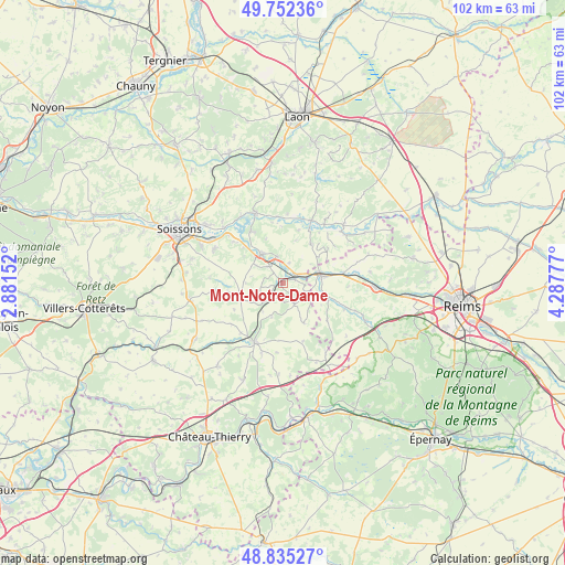
Mont-Notre-Dame GPS coordinates[2]
49° 17' 45.42" North, 3° 35' 4.704" East
| Map corner | latitude | longitude |
|---|---|---|
| Upper-left | 49.75236°, | 2.88152° |
| Center: | 49.29595°, | 3.58464° |
| Lower-right: | 48.83527°, | 4.28777° |
| Map W x H: | 102×102 km | = 63.4×63.4mi |
| max Lat: | 51.07786° ⇑14% North |
| Mont-Notre-Dame: | 49.29595° |
| min Lat: | ⇓86% South 41.3874° |
| min Long | Mont-Notre-Dame | max Long |
| -5.08615° | 3.58464° | 9.52242° |
| W 64.9%⇐ | ⇒35.1% E |
Elevation
Elevation of Mont-Notre-Dame is 77 m = 253 ft, and this is 116.7 m = 383 ft below average elevation for this country.
| Max E: |
2333 m = 7654 ft | 70.5% |
| Avg. | 193.7 m = 635 ft | |
| Mont-Notre-Dame | 77 m = 253 ft | |
Min E: |
-1 m = -3 ft | 29.5% |
See also: France elevation on elevation.city.
Geographical zone
Mont-Notre-Dame is located in North temperate zone (between Tropic of Cancer and the Arctic Circle). Distance of this North polar circle is 1920 km =1193 mi to North.| Distance of | km | miles | from Mont-Notre-Dame |
|---|---|---|---|
| North Pole | 4525.9 | 2812.3 | to North |
| Arctic Circle | 1920 | 1193 | to North |
| Tropic Cancer | 2875.3 | 1786.6 | to South |
| Equator | 5481.2 | 3405.9 | to South |


Nearby cities:
15 places around Mont-Notre-Dame: (largest is in red/bold)
• Acy
13.7 km =8.5 mi,  293°
293°
• Beaurieux
15.6 km =9.7 mi,  46°
46°
• Billy-sur-Aisne
16 km =9.9 mi, 294°
• Bourg-et-Comin
12.3 km =7.6 mi,  24°
24°
• Braine
6.4 km =4 mi,  323°
323°
• Chassemy
11 km =6.8 mi,  329°
329°
• Chivres-Val
15.5 km =9.6 mi, 315°
• Ciry-Salsogne
11.6 km =7.2 mi,  310°
310°
• Crugny
12.1 km =7.5 mi,  112°
112°
• Fismes
7.5 km =4.7 mi,  79°
79°
• Fère-en-Tardenois
11.8 km =7.3 mi,  204°
204°
• Jonchery-sur-Vesle
16.6 km =10.3 mi,  92°
92°
• Missy-sur-Aisne
14.8 km =9.2 mi, 313°
• Vailly-sur-Aisne
13.4 km =8.3 mi,  338°
338°
• Venizel
15.9 km =9.9 mi,  299°
299°
Sources, notices
• [Note1] Compared only with cities in France existing in our database
• [Src1] Map data: © OpenStreetMap contributors (CC-BY-SA)
• [Src2] Other city data from geonames.org with taken over terms of usage.
• [Src3] Geographical zone / Annual Mean Temperature by Robert A. Rohde @ Wikipedia
