Châtellerault geodata
Châtellerault (Nouvelle-Aquitaine) is a seat of a third-order administrative division; located in France in Europe/Paris (GMT+2) time zone. With population of 37,210 people, there are 206 cities with bigger population in this country. Compared to other cities in France, 57% of cities are located further ↑North; 73% of cities are located further →East and 76.6% of cities have higher elevation than Châtellerault. Note1
Administrative division(s):
- Level 1: Nouvelle-Aquitaine
- Level 2: Vienne
- Level 3: Arrondissement de Châtellerault
- Level 4: Châtellerault


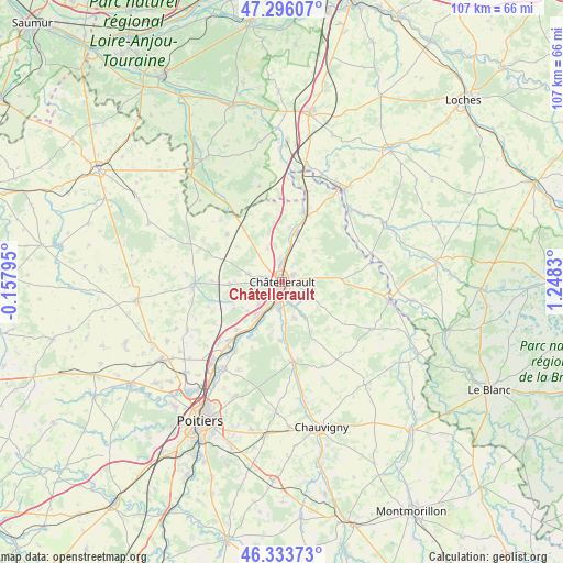
Châtellerault GPS coordinates[2]
46° 49' 1.38" North, 0° 32' 42.648" East
| Map corner | latitude | longitude |
|---|---|---|
| Upper-left | 47.29607°, | -0.15795° |
| Center: | 46.81705°, | 0.54518° |
| Lower-right: | 46.33373°, | 1.2483° |
| Map W x H: | 107×107 km | = 66.5×66.5mi |
| max Lat: | 51.07786° ⇑57% North |
| Châtellerault: | 46.81705° |
| min Lat: | ⇓43% South 41.3874° |
| min Long | Châtellerault | max Long |
| -5.08615° | 0.54518° | 9.52242° |
| W 27%⇐ | ⇒73% E |
Elevation
Elevation of Châtellerault is 63 m = 207 ft, and this is 130.7 m = 429 ft below average elevation for this country.
| Max E: |
2333 m = 7654 ft | 76.6% |
| Avg. | 193.7 m = 635 ft | |
| Châtellerault | 63 m = 207 ft | |
Min E: |
-1 m = -3 ft | 23.4% |
See also: France elevation on elevation.city.
Geographical zone
Châtellerault is located in North temperate zone (between Tropic of Cancer and the Arctic Circle). Distance of this North polar circle is 2195.6 km =1364.3 mi to North.| Distance of | km | miles | from Châtellerault |
|---|---|---|---|
| North Pole | 4801.5 | 2983.5 | to North |
| Arctic Circle | 2195.6 | 1364.3 | to North |
| Tropic Cancer | 2599.6 | 1615.3 | to South |
| Equator | 5205.6 | 3234.6 | to South |


Nearby cities:
15 places around Châtellerault: (largest is in red/bold)
• Antran
4.2 km =2.6 mi,  356°
356°
• Beaumont
12.5 km =7.8 mi,  224°
224°
• Cenon-sur-Vienne
4.8 km =3 mi,  187°
187°
• Colombiers
10.4 km =6.5 mi,  241°
241°
• Monthoiron
10.9 km =6.8 mi,  148°
148°
• Naintré
7.7 km =4.8 mi, 218°
• Oyré
8.8 km =5.5 mi,  45°
45°
• Saint-Cyr
13.5 km =8.4 mi, 215°
• Saint-Sauveur
6 km =3.7 mi,  99°
99°
• Scorbé-Clairvaux
10 km =6.2 mi,  267°
267°
• Senillé
6.8 km =4.2 mi,  129°
129°
• Thuré
6.7 km =4.2 mi,  284°
284°
• Usseau
7.1 km =4.4 mi,  337°
337°
• Vaux-sur-Vienne
10.8 km =6.7 mi,  8°
8°
• Vouneuil-sur-Vienne
11.1 km =6.9 mi,  181°
181°
Sources, notices
• [Note1] Compared only with cities in France existing in our database
• [Src1] Map data: © OpenStreetMap contributors (CC-BY-SA)
• [Src2] Other city data from geonames.org with taken over terms of usage.
• [Src3] Geographical zone / Annual Mean Temperature by Robert A. Rohde @ Wikipedia
