Villeneuve-lès-Avignon geodata
Villeneuve-lès-Avignon (Occitanie) is a populated place; located in France in Europe/Paris (GMT+2) time zone. With population of 13,451 people, there are 709 cities with bigger population in this country. Compared to other cities in France, 87.3% of cities are located further ↑North; 75% of cities are located further ←West and 93.6% of cities have higher elevation than Villeneuve-lès-Avignon. Note1
Administrative division(s):
- Level 1: Occitanie
- Level 2: Gard
- Level 3: Arrondissement de Nîmes
- Level 4: Villeneuve-lès-Avignon
Current local time in Villeneuve-lès-Avignon:
01:40 PM, WednesdayDifference from your time zone: hours


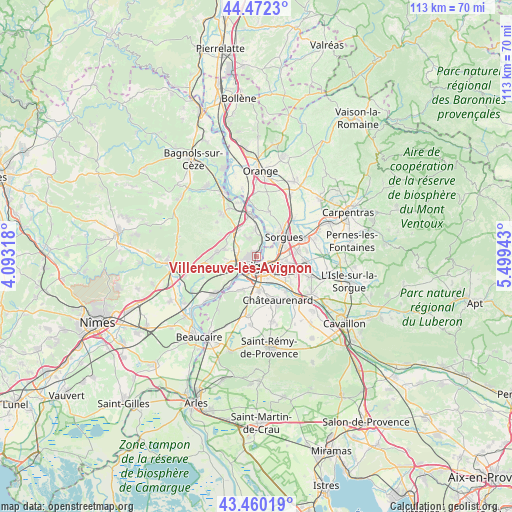
Villeneuve-lès-Avignon GPS coordinates[2]
43° 58' 6.24" North, 4° 47' 46.68" East
| Map corner | latitude | longitude |
|---|---|---|
| Upper-left | 44.4723°, | 4.09318° |
| Center: | 43.9684°, | 4.7963° |
| Lower-right: | 43.46019°, | 5.49943° |
| Map W x H: | 112.5×112.5 km | = 69.9×69.9mi |
| max Lat: | 51.07786° ⇑87.3% North |
| Villeneuve-lès-Avignon: | 43.9684° |
| min Lat: | ⇓12.7% South 41.3874° |
| min Long | Villeneuve-lès | max Long |
| -5.08615° | 4.7963° | 9.52242° |
| W 75%⇐ | ⇒25% E |
Elevation
Elevation of Villeneuve-lès-Avignon is 21 m = 69 ft, and this is 172.7 m = 567 ft below average elevation for this country.
| Max E: |
2333 m = 7654 ft | 93.6% |
| Avg. | 193.7 m = 635 ft | |
| Villeneuve-lès-Avignon | 21 m = 69 ft | |
Min E: |
-1 m = -3 ft | 6.4% |
See also: France elevation on elevation.city.
Geographical zone
Villeneuve-lès-Avignon is located in North temperate zone (between Tropic of Cancer and the Arctic Circle). Distance of this Northern Tropic circle is 2282.9 km =1418.5 mi to South.| Distance of | km | miles | from Villeneuve-lès-Avignon |
|---|---|---|---|
| North Pole | 5118.2 | 3180.3 | to North |
| Arctic Circle | 2512.3 | 1561.1 | to North |
| Tropic Cancer | 2282.9 | 1418.5 | to South |
| Equator | 4888.8 | 3037.8 | to South |


Nearby cities:
15 places around Villeneuve-lès-Avignon: (largest is in red/bold)
• Avignon
2.4 km =1.5 mi,  155°
155°
• Barbentane
8.6 km =5.3 mi,  206°
206°
• Le Pontet
5.2 km =3.2 mi,  98°
98°
• Les Angles
2.9 km =1.8 mi,  246°
246°
• Montfavet
7.3 km =4.5 mi,  122°
122°
• Morières-lès-Avignon
9 km =5.6 mi,  110°
110°
• Pujaut
4.3 km =2.7 mi,  337°
337°
• Rochefort-du-Gard
8.5 km =5.3 mi,  276°
276°
• Rognonas
7.6 km =4.7 mi,  175°
175°
• Roquemaure
9.1 km =5.7 mi,  350°
350°
• Sauveterre
6.1 km =3.8 mi,  357°
357°
• Saze
9.6 km =6 mi, 253°
• Sorgues
7.8 km =4.8 mi,  53°
53°
• Tavel
9.3 km =5.8 mi,  302°
302°
• Vedène
8.7 km =5.4 mi,  83°
83°
Sources, notices
• [Note1] Compared only with cities in France existing in our database
• [Src1] Map data: © OpenStreetMap contributors (CC-BY-SA)
• [Src2] Other city data from geonames.org with taken over terms of usage.
• [Src3] Geographical zone / Annual Mean Temperature by Robert A. Rohde @ Wikipedia
