Malaunay geodata
Malaunay (Normandy) is a populated place; located in France in Europe/Paris (GMT+2) time zone. With population of 5,943 people, there are 1662 cities with bigger population in this country. Compared to other cities in France, 89.7% of cities are located further ↓South; 68.3% of cities are located further →East and 85.9% of cities have higher elevation than Malaunay. Note1
Administrative division(s):
- Level 1: Normandy
- Level 2: Seine-Maritime
- Level 3: Arrondissement de Rouen
- Level 4: Malaunay


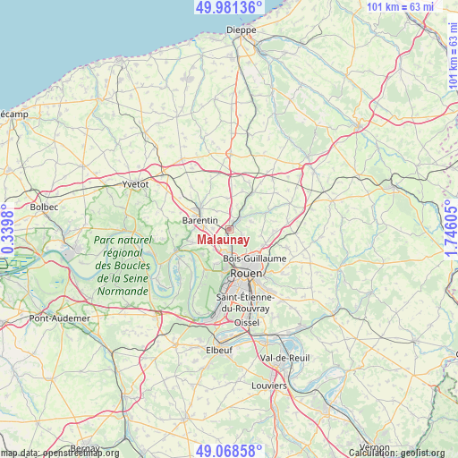
Malaunay GPS coordinates[2]
49° 31' 37.56" North, 1° 2' 34.512" East
| Map corner | latitude | longitude |
|---|---|---|
| Upper-left | 49.98136°, | 0.3398° |
| Center: | 49.5271°, | 1.04292° |
| Lower-right: | 49.06858°, | 1.74605° |
| Map W x H: | 101.5×101.5 km | = 63.1×63.1mi |
| max Lat: | 51.07786° ⇑10.3% North |
| Malaunay: | 49.5271° |
| min Lat: | ⇓89.7% South 41.3874° |
| min Long | Malaunay | max Long |
| -5.08615° | 1.04292° | 9.52242° |
| W 31.7%⇐ | ⇒68.3% E |
Elevation
Elevation of Malaunay is 40 m = 131 ft, and this is 153.7 m = 504 ft below average elevation for this country.
| Max E: |
2333 m = 7654 ft | 85.9% |
| Avg. | 193.7 m = 635 ft | |
| Malaunay | 40 m = 131 ft | |
Min E: |
-1 m = -3 ft | 14.1% |
See also: France elevation on elevation.city.
Geographical zone
Malaunay is located in North temperate zone (between Tropic of Cancer and the Arctic Circle). Distance of this North polar circle is 1894.3 km =1177.1 mi to North.| Distance of | km | miles | from Malaunay |
|---|---|---|---|
| North Pole | 4500.2 | 2796.3 | to North |
| Arctic Circle | 1894.3 | 1177.1 | to North |
| Tropic Cancer | 2901 | 1802.6 | to South |
| Equator | 5506.9 | 3421.8 | to South |


Nearby cities:
15 places around Malaunay: (largest is in red/bold)
• Anceaumeville
5 km =3.1 mi,  6°
6°
• Barentin
6.6 km =4.1 mi,  287°
287°
• Bosc-Guérard-Saint-Adrien
5.5 km =3.4 mi,  73°
73°
• Déville-lès-Rouen
6.4 km =4 mi,  174°
174°
• Eslettes
2.5 km =1.6 mi,  20°
20°
• Houppeville
3.1 km =1.9 mi,  121°
121°
• La Vaupalière
5.5 km =3.4 mi,  217°
217°
• Le Houlme
2 km =1.2 mi,  195°
195°
• Maromme
5.5 km =3.4 mi,  194°
194°
• Mont-Cauvaire
6.8 km =4.2 mi,  44°
44°
• Notre-Dame-de-Bondeville
4.9 km =3 mi, 174°
• Pissy-Pôville
3.6 km =2.2 mi,  274°
274°
• Roumare
5.3 km =3.3 mi,  249°
249°
• Saint-Jean-du-Cardonnay
3.4 km =2.1 mi, 222°
• Sierville
7 km =4.3 mi,  355°
355°
Sources, notices
• [Note1] Compared only with cities in France existing in our database
• [Src1] Map data: © OpenStreetMap contributors (CC-BY-SA)
• [Src2] Other city data from geonames.org with taken over terms of usage.
• [Src3] Geographical zone / Annual Mean Temperature by Robert A. Rohde @ Wikipedia
