Chevagnes geodata
Chevagnes (Auvergne-Rhône-Alpes) is a populated place; located in France in Europe/Paris (GMT+2) time zone. With population of 734 people, there are 11362 cities with bigger population in this country. Compared to other cities in France, 59.1% of cities are located further ↑North; 64.7% of cities are located further ←West and 71% of cities have lower elevation than Chevagnes. Note1
Administrative division(s):
- Level 1: Auvergne-Rhône-Alpes
- Level 2: Département de l'Allier
- Level 3: Arrondissement de Moulins
- Level 4: Chevagnes


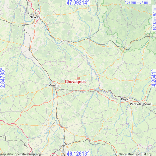
Chevagnes GPS coordinates[2]
46° 36' 40.644" North, 3° 33' 3.492" East
| Map corner | latitude | longitude |
|---|---|---|
| Upper-left | 47.09214°, | 2.84785° |
| Center: | 46.61129°, | 3.55097° |
| Lower-right: | 46.12613°, | 4.2541° |
| Map W x H: | 107.4×107.4 km | = 66.7×66.7mi |
| max Lat: | 51.07786° ⇑59.1% North |
| Chevagnes: | 46.61129° |
| min Lat: | ⇓40.9% South 41.3874° |
| min Long | Chevagnes | max Long |
| -5.08615° | 3.55097° | 9.52242° |
| W 64.7%⇐ | ⇒35.3% E |
Elevation
Elevation of Chevagnes is 224 m = 735 ft, and this is 30.3 m = 99 ft above average elevation for this country.
| Max E: |
2333 m = 7654 ft | 29% |
| Chevagnes | 224 m 735 ft | |
| Avg. | 193.7 m = 635 ft | |
Min E: |
-1 m = -3 ft | 71% |
See also: France elevation on elevation.city.
Geographical zone
Chevagnes is located in North temperate zone (between Tropic of Cancer and the Arctic Circle). Distance of this North polar circle is 2218.5 km =1378.5 mi to North.| Distance of | km | miles | from Chevagnes |
|---|---|---|---|
| North Pole | 4824.4 | 2997.7 | to North |
| Arctic Circle | 2218.5 | 1378.5 | to North |
| Tropic Cancer | 2576.8 | 1601.1 | to South |
| Equator | 5182.7 | 3220.4 | to South |


Nearby cities:
15 places around Chevagnes: (largest is in red/bold)
• Beaulon
9.4 km =5.8 mi,  96°
96°
• Bourbon-Lancy
16.7 km =10.4 mi,  85°
85°
• Cossaye
16.1 km =10 mi,  341°
341°
• Cronat
16.1 km =10 mi,  39°
39°
• Diou
17.1 km =10.6 mi,  120°
120°
• Dompierre-sur-Besbre
14 km =8.7 mi,  134°
134°
• Garnat-sur-Engièvre
8.9 km =5.5 mi,  73°
73°
• Lucenay-lès-Aix
11.4 km =7.1 mi,  332°
332°
• Lusigny
5.2 km =3.2 mi,  240°
240°
• Montbeugny
10.3 km =6.4 mi,  207°
207°
• Moulins
17.5 km =10.9 mi,  252°
252°
• Saint-Ennemond
12.2 km =7.6 mi,  306°
306°
• Thiel-sur-Acolin
10.1 km =6.3 mi,  166°
166°
• Toulon-sur-Allier
17.9 km =11.1 mi,  234°
234°
• Yzeure
15.8 km =9.8 mi, 251°
Sources, notices
• [Note1] Compared only with cities in France existing in our database
• [Src1] Map data: © OpenStreetMap contributors (CC-BY-SA)
• [Src2] Other city data from geonames.org with taken over terms of usage.
• [Src3] Geographical zone / Annual Mean Temperature by Robert A. Rohde @ Wikipedia
