Bézenet geodata
Bézenet (Auvergne-Rhône-Alpes) is a populated place; located in France in Europe/Paris (GMT+2) time zone. With population of 987 people, there are 8931 cities with bigger population in this country. Compared to other cities in France, 61.9% of cities are located further ↑North; 55.6% of cities are located further ←West and 83.3% of cities have lower elevation than Bézenet. Note1
Administrative division(s):
- Level 1: Auvergne-Rhône-Alpes
- Level 2: Département de l'Allier
- Level 3: Arrondissement de Montluçon
- Level 4: Bézenet


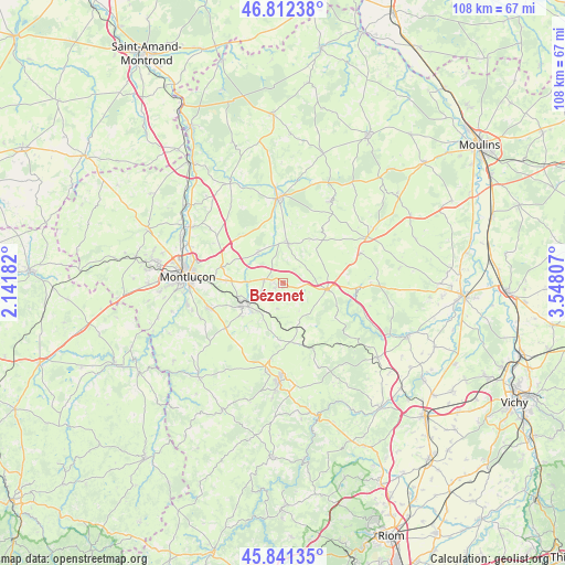
Bézenet GPS coordinates[2]
46° 19' 44.472" North, 2° 50' 41.82" East
| Map corner | latitude | longitude |
|---|---|---|
| Upper-left | 46.81238°, | 2.14182° |
| Center: | 46.32902°, | 2.84495° |
| Lower-right: | 45.84135°, | 3.54807° |
| Map W x H: | 108×108 km | = 67.1×67.1mi |
| max Lat: | 51.07786° ⇑61.9% North |
| Bézenet: | 46.32902° |
| min Lat: | ⇓38.1% South 41.3874° |
| min Long | Bézenet | max Long |
| -5.08615° | 2.84495° | 9.52242° |
| W 55.6%⇐ | ⇒44.4% E |
Elevation
Elevation of Bézenet is 325 m = 1066 ft, and this is 131.3 m = 431 ft above average elevation for this country.
| Max E: |
2333 m = 7654 ft | 16.7% |
| Bézenet | 325 m 1066 ft | |
| Avg. | 193.7 m = 635 ft | |
Min E: |
-1 m = -3 ft | 83.3% |
See also: France elevation on elevation.city.
Geographical zone
Bézenet is located in North temperate zone (between Tropic of Cancer and the Arctic Circle). Distance of this North polar circle is 2249.9 km =1398 mi to North.| Distance of | km | miles | from Bézenet |
|---|---|---|---|
| North Pole | 4855.8 | 3017.3 | to North |
| Arctic Circle | 2249.9 | 1398 | to North |
| Tropic Cancer | 2545.4 | 1581.6 | to South |
| Equator | 5151.3 | 3200.9 | to South |


Nearby cities:
15 places around Bézenet: (largest is in red/bold)
• Buxières-les-Mines
17.8 km =11.1 mi,  29°
29°
• Chamblet
11 km =6.8 mi,  272°
272°
• Commentry
9.1 km =5.7 mi,  240°
240°
• Doyet
3.7 km =2.3 mi,  281°
281°
• Désertines
17.6 km =10.9 mi, 279°
• Lapeyrouse
11.8 km =7.3 mi,  169°
169°
• Larequille
14 km =8.7 mi,  232°
232°
• Malicorne
5.7 km =3.5 mi, 237°
• Montaigut
16.9 km =10.5 mi,  189°
189°
• Montmarault
8.5 km =5.3 mi,  98°
98°
• Montvicq
2.1 km =1.3 mi, 240°
• Néris-les-Bains
15.1 km =9.4 mi,  251°
251°
• Verneix
15.4 km =9.6 mi,  299°
299°
• Villebret
17.3 km =10.7 mi, 246°
• Villefranche-d’Allier
7.6 km =4.7 mi,  7°
7°
Sources, notices
• [Note1] Compared only with cities in France existing in our database
• [Src1] Map data: © OpenStreetMap contributors (CC-BY-SA)
• [Src2] Other city data from geonames.org with taken over terms of usage.
• [Src3] Geographical zone / Annual Mean Temperature by Robert A. Rohde @ Wikipedia
