Lavergne geodata
Lavergne (Nouvelle-Aquitaine) is a populated place; located in France in Europe/Paris (GMT+2) time zone. With population of 567 people, there are 13878 cities with bigger population in this country. Compared to other cities in France, 82.9% of cities are located further ↑North; 74.4% of cities are located further →East and 76.6% of cities have higher elevation than Lavergne. Note1
Administrative division(s):
- Level 1: Nouvelle-Aquitaine
- Level 2: Département du Lot-et-Garonne
- Level 3: Arrondissement de Marmande
- Level 4: Lavergne


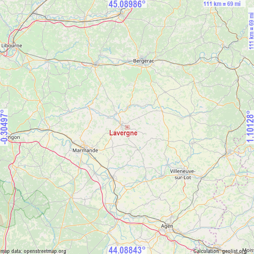
Lavergne GPS coordinates[2]
44° 35' 28.68" North, 0° 23' 53.376" East
| Map corner | latitude | longitude |
|---|---|---|
| Upper-left | 45.08986°, | -0.30497° |
| Center: | 44.5913°, | 0.39816° |
| Lower-right: | 44.08843°, | 1.10128° |
| Map W x H: | 111.3×111.3 km | = 69.2×69.2mi |
| max Lat: | 51.07786° ⇑82.9% North |
| Lavergne: | 44.5913° |
| min Lat: | ⇓17.1% South 41.3874° |
| min Long | Lavergne | max Long |
| -5.08615° | 0.39816° | 9.52242° |
| W 25.6%⇐ | ⇒74.4% E |
Elevation
Elevation of Lavergne is 63 m = 207 ft, and this is 130.7 m = 429 ft below average elevation for this country.
| Max E: |
2333 m = 7654 ft | 76.6% |
| Avg. | 193.7 m = 635 ft | |
| Lavergne | 63 m = 207 ft | |
Min E: |
-1 m = -3 ft | 23.4% |
See also: France elevation on elevation.city.
Geographical zone
Lavergne is located in North temperate zone (between Tropic of Cancer and the Arctic Circle). Distance of this Northern Tropic circle is 2352.2 km =1461.6 mi to South.| Distance of | km | miles | from Lavergne |
|---|---|---|---|
| North Pole | 5049 | 3137.3 | to North |
| Arctic Circle | 2443.1 | 1518.1 | to North |
| Tropic Cancer | 2352.2 | 1461.6 | to South |
| Equator | 4958.1 | 3080.8 | to South |


Nearby cities:
15 places around Lavergne: (largest is in red/bold)
• Birac-sur-Trec
15.7 km =9.8 mi,  221°
221°
• Castillonnès
16.8 km =10.4 mi,  66°
66°
• Escassefort
13.5 km =8.4 mi,  249°
249°
• Eymet
8.5 km =5.3 mi,  0°
0°
• Fongrave
6.4 km =4 mi,  178°
178°
• Gontaud-de-Nogaret
17.5 km =10.9 mi,  206°
206°
• Lauzun
6.6 km =4.1 mi,  49°
49°
• Lévignac-de-Guyenne
16.2 km =10.1 mi,  284°
284°
• Miramont-de-Guyenne
3 km =1.9 mi,  292°
292°
• Monbahus
11.9 km =7.4 mi,  113°
113°
• Puymiclan
10.9 km =6.8 mi, 216°
• Roumagne
5.6 km =3.5 mi,  302°
302°
• Saint-Pardoux-Isaac
3 km =1.9 mi,  319°
319°
• Seyches
8.5 km =5.3 mi,  238°
238°
• Virazeil
16.8 km =10.4 mi, 236°
Sources, notices
• [Note1] Compared only with cities in France existing in our database
• [Src1] Map data: © OpenStreetMap contributors (CC-BY-SA)
• [Src2] Other city data from geonames.org with taken over terms of usage.
• [Src3] Geographical zone / Annual Mean Temperature by Robert A. Rohde @ Wikipedia
