Mertzwiller geodata
Mertzwiller (Grand Est) is a populated place; located in France in Europe/Paris (GMT+2) time zone. With population of 3,716 people, there are 2643 cities with bigger population in this country. Compared to other cities in France, 76.9% of cities are located further ↓South; 98.9% of cities are located further ←West and 56.8% of cities have lower elevation than Mertzwiller. Note1
Administrative division(s):
- Level 1: Grand Est
- Level 2: Bas-Rhin
- Level 3: Arrondissement de Haguenau-Wissembourg
- Level 4: Mertzwiller


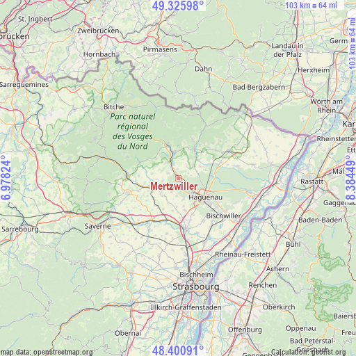
Mertzwiller GPS coordinates[2]
48° 51' 56.088" North, 7° 40' 52.896" East
| Map corner | latitude | longitude |
|---|---|---|
| Upper-left | 49.32598°, | 6.97824° |
| Center: | 48.86558°, | 7.68136° |
| Lower-right: | 48.40091°, | 8.38449° |
| Map W x H: | 102.9×102.9 km | = 63.9×63.9mi |
| max Lat: | 51.07786° ⇑23.1% North |
| Mertzwiller: | 48.86558° |
| min Lat: | ⇓76.9% South 41.3874° |
| min Long | Mertzwiller | max Long |
| -5.08615° | 7.68136° | 9.52242° |
| W 98.9%⇐ | ⇒1.1% E |
Elevation
Elevation of Mertzwiller is 157 m = 515 ft, and this is 36.7 m = 120 ft below average elevation for this country.
| Max E: |
2333 m = 7654 ft | 43.2% |
| Avg. | 193.7 m = 635 ft | |
| Mertzwiller | 157 m = 515 ft | |
Min E: |
-1 m = -3 ft | 56.8% |
See also: France elevation on elevation.city.
Geographical zone
Mertzwiller is located in North temperate zone (between Tropic of Cancer and the Arctic Circle). Distance of this North polar circle is 1967.8 km =1222.7 mi to North.| Distance of | km | miles | from Mertzwiller |
|---|---|---|---|
| North Pole | 4573.7 | 2842 | to North |
| Arctic Circle | 1967.8 | 1222.7 | to North |
| Tropic Cancer | 2827.4 | 1756.9 | to South |
| Equator | 5433.3 | 3376.1 | to South |


Nearby cities:
15 places around Mertzwiller: (largest is in red/bold)
• Dauendorf
4.4 km =2.7 mi,  205°
205°
• Durrenbach
7.2 km =4.5 mi,  61°
61°
• Eschbach
4.1 km =2.5 mi,  75°
75°
• Forstheim
4.1 km =2.5 mi,  37°
37°
• Gumbrechtshoffen
5.9 km =3.7 mi,  319°
319°
• Gundershoffen
4.8 km =3 mi,  341°
341°
• Kindwiller
6.2 km =3.9 mi,  266°
266°
• Mietesheim
3.3 km =2.1 mi,  296°
296°
• Morsbronn-les-Bains
6.1 km =3.8 mi,  48°
48°
• Niedermodern
4.6 km =2.9 mi,  240°
240°
• Ohlungen
6 km =3.7 mi,  165°
165°
• Pfaffenhoffen
6 km =3.7 mi, 244°
• Schweighouse-sur-Moder
6.1 km =3.8 mi,  145°
145°
• Uberach
4.2 km =2.6 mi,  245°
245°
• Uhlwiller
5 km =3.1 mi,  186°
186°
Sources, notices
• [Note1] Compared only with cities in France existing in our database
• [Src1] Map data: © OpenStreetMap contributors (CC-BY-SA)
• [Src2] Other city data from geonames.org with taken over terms of usage.
• [Src3] Geographical zone / Annual Mean Temperature by Robert A. Rohde @ Wikipedia
