Uberach geodata
Uberach (Grand Est) is a populated place; located in France in Europe/Paris (GMT+2) time zone. With population of 1,159 people, there are 7770 cities with bigger population in this country. Compared to other cities in France, 76.6% of cities are located further ↓South; 98.7% of cities are located further ←West and 58.7% of cities have lower elevation than Uberach. Note1
Administrative division(s):
- Level 1: Grand Est
- Level 2: Bas-Rhin
- Level 3: Arrondissement de Haguenau-Wissembourg
- Level 4: Val-de-Moder


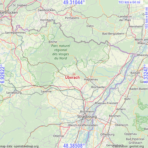
Uberach GPS coordinates[2]
48° 50' 59.64" North, 7° 37' 45.624" East
| Map corner | latitude | longitude |
|---|---|---|
| Upper-left | 49.31044°, | 6.92622° |
| Center: | 48.8499°, | 7.62934° |
| Lower-right: | 48.38508°, | 8.33247° |
| Map W x H: | 102.9×102.9 km | = 63.9×63.9mi |
| max Lat: | 51.07786° ⇑23.4% North |
| Uberach: | 48.8499° |
| min Lat: | ⇓76.6% South 41.3874° |
| min Long | Uberach | max Long |
| -5.08615° | 7.62934° | 9.52242° |
| W 98.7%⇐ | ⇒1.3% E |
Elevation
Elevation of Uberach is 164 m = 538 ft, and this is 29.7 m = 97 ft below average elevation for this country.
| Max E: |
2333 m = 7654 ft | 41.3% |
| Avg. | 193.7 m = 635 ft | |
| Uberach | 164 m = 538 ft | |
Min E: |
-1 m = -3 ft | 58.7% |
See also: France elevation on elevation.city.
Geographical zone
Uberach is located in North temperate zone (between Tropic of Cancer and the Arctic Circle). Distance of this North polar circle is 1969.6 km =1223.9 mi to North.| Distance of | km | miles | from Uberach |
|---|---|---|---|
| North Pole | 4575.5 | 2843.1 | to North |
| Arctic Circle | 1969.6 | 1223.9 | to North |
| Tropic Cancer | 2825.7 | 1755.8 | to South |
| Equator | 5431.6 | 3375 | to South |


Nearby cities:
15 places around Uberach: (largest is in red/bold)
• Alteckendorf
6.9 km =4.3 mi,  200°
200°
• Dauendorf
2.9 km =1.8 mi,  139°
139°
• Ettendorf
5.4 km =3.4 mi,  219°
219°
• Gumbrechtshoffen
6.2 km =3.9 mi,  359°
359°
• Gundershoffen
6.7 km =4.2 mi,  20°
20°
• Kindwiller
2.8 km =1.7 mi,  300°
300°
• Mertzwiller
4.2 km =2.6 mi,  65°
65°
• Mietesheim
3.3 km =2.1 mi, 15°
• Minversheim
7.2 km =4.5 mi,  184°
184°
• Niedermodern
0.6 km =0.4 mi, 199°
• Obermodern-Zutzendorf
7 km =4.3 mi,  270°
270°
• Ohlungen
6.7 km =4.2 mi,  127°
127°
• Pfaffenhoffen
1.8 km =1.1 mi,  242°
242°
• Uhlwiller
4.6 km =2.9 mi, 134°
• Uhrwiller
4.9 km =3 mi,  309°
309°
Sources, notices
• [Note1] Compared only with cities in France existing in our database
• [Src1] Map data: © OpenStreetMap contributors (CC-BY-SA)
• [Src2] Other city data from geonames.org with taken over terms of usage.
• [Src3] Geographical zone / Annual Mean Temperature by Robert A. Rohde @ Wikipedia
