Lanvaudan geodata
Lanvaudan (Brittany) is a populated place; located in France in Europe/Paris (GMT+2) time zone. With population of 781 people, there are 10811 cities with bigger population in this country. Compared to other cities in France, 57.5% of cities are located further ↓South; 97.9% of cities are located further →East and 65.6% of cities have higher elevation than Lanvaudan. Note1
Administrative division(s):
- Level 1: Brittany
- Level 2: Morbihan
- Level 3: Arrondissement de Lorient
- Level 4: Lanvaudan


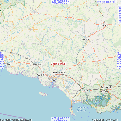
Lanvaudan GPS coordinates[2]
47° 53' 57.768" North, 3° 15' 42.3" West
| Map corner | latitude | longitude |
|---|---|---|
| Upper-left | 48.36863°, | -3.96488° |
| Center: | 47.89938°, | -3.26175° |
| Lower-right: | 47.42583°, | -2.55863° |
| Map W x H: | 104.8×104.8 km | = 65.1×65.1mi |
| max Lat: | 51.07786° ⇑42.5% North |
| Lanvaudan: | 47.89938° |
| min Lat: | ⇓57.5% South 41.3874° |
| min Long | Lanvaudan | max Long |
| -5.08615° | -3.26175° | 9.52242° |
| W 2.1%⇐ | ⇒97.9% E |
Elevation
Elevation of Lanvaudan is 88 m = 289 ft, and this is 105.7 m = 347 ft below average elevation for this country.
| Max E: |
2333 m = 7654 ft | 65.6% |
| Avg. | 193.7 m = 635 ft | |
| Lanvaudan | 88 m = 289 ft | |
Min E: |
-1 m = -3 ft | 34.4% |
See also: France elevation on elevation.city.
Geographical zone
Lanvaudan is located in North temperate zone (between Tropic of Cancer and the Arctic Circle). Distance of this North polar circle is 2075.3 km =1289.5 mi to North.| Distance of | km | miles | from Lanvaudan |
|---|---|---|---|
| North Pole | 4681.2 | 2908.8 | to North |
| Arctic Circle | 2075.3 | 1289.5 | to North |
| Tropic Cancer | 2720 | 1690.1 | to South |
| Equator | 5325.9 | 3309.4 | to South |


Nearby cities:
15 places around Lanvaudan: (largest is in red/bold)
• Arzano
13.3 km =8.3 mi,  270°
270°
• Berné
14.5 km =9 mi,  317°
317°
• Brandérion
12.7 km =7.9 mi,  156°
156°
• Bubry
9.8 km =6.1 mi,  43°
43°
• Calan
5.2 km =3.2 mi,  239°
239°
• Caudan
11.7 km =7.3 mi,  210°
210°
• Cléguer
10.3 km =6.4 mi, 240°
• Hennebont
10.5 km =6.5 mi,  184°
184°
• Inguiniel
8.7 km =5.4 mi,  350°
350°
• Kervignac
15.3 km =9.5 mi,  173°
173°
• Languidic
10.7 km =6.6 mi,  133°
133°
• Melrand
14.5 km =9 mi,  51°
51°
• Plouay
5.6 km =3.5 mi,  287°
287°
• Pont-Scorff
12.8 km =8 mi, 235°
• Quistinic
9.5 km =5.9 mi,  86°
86°
Sources, notices
• [Note1] Compared only with cities in France existing in our database
• [Src1] Map data: © OpenStreetMap contributors (CC-BY-SA)
• [Src2] Other city data from geonames.org with taken over terms of usage.
• [Src3] Geographical zone / Annual Mean Temperature by Robert A. Rohde @ Wikipedia
