Pange geodata
Pange (Grand Est) is a populated place; located in France in Europe/Paris (GMT+2) time zone. With population of 811 people, there are 10468 cities with bigger population in this country. Compared to other cities in France, 81.8% of cities are located further ↓South; 90.7% of cities are located further ←West and 69.2% of cities have lower elevation than Pange. Note1
Administrative division(s):
- Level 1: Grand Est
- Level 2: Moselle
- Level 3: Arrondissement de Metz
- Level 4: Pange


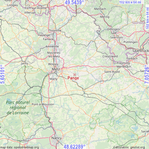
Pange GPS coordinates[2]
49° 5' 7.908" North, 6° 21' 14.868" East
| Map corner | latitude | longitude |
|---|---|---|
| Upper-left | 49.5439°, | 5.65101° |
| Center: | 49.08553°, | 6.35413° |
| Lower-right: | 48.62289°, | 7.05726° |
| Map W x H: | 102.4×102.4 km | = 63.6×63.6mi |
| max Lat: | 51.07786° ⇑18.2% North |
| Pange: | 49.08553° |
| min Lat: | ⇓81.8% South 41.3874° |
| min Long | Pange | max Long |
| -5.08615° | 6.35413° | 9.52242° |
| W 90.7%⇐ | ⇒9.3% E |
Elevation
Elevation of Pange is 215 m = 705 ft, and this is 21.3 m = 70 ft above average elevation for this country.
| Max E: |
2333 m = 7654 ft | 30.8% |
| Pange | 215 m 705 ft | |
| Avg. | 193.7 m = 635 ft | |
Min E: |
-1 m = -3 ft | 69.2% |
See also: France elevation on elevation.city.
Geographical zone
Pange is located in North temperate zone (between Tropic of Cancer and the Arctic Circle). Distance of this North polar circle is 1943.4 km =1207.6 mi to North.| Distance of | km | miles | from Pange |
|---|---|---|---|
| North Pole | 4549.3 | 2826.8 | to North |
| Arctic Circle | 1943.4 | 1207.6 | to North |
| Tropic Cancer | 2851.9 | 1772.1 | to South |
| Equator | 5457.8 | 3391.3 | to South |


Nearby cities:
15 places around Pange: (largest is in red/bold)
• Ars-Laquenexy
6.2 km =3.9 mi,  278°
278°
• Condé
9.4 km =5.8 mi,  36°
36°
• Courcelles-Chaussy
4.4 km =2.7 mi,  52°
52°
• Courcelles-sur-Nied
4 km =2.5 mi,  237°
237°
• Failly
10.5 km =6.5 mi,  319°
319°
• Jury
7.6 km =4.7 mi,  256°
256°
• Laquenexy
3 km =1.9 mi,  254°
254°
• Mécleuves
7.6 km =4.7 mi,  233°
233°
• Noisseville
7.9 km =4.9 mi,  313°
313°
• Peltre
9.3 km =5.8 mi, 262°
• Retonfey
6.6 km =4.1 mi,  328°
328°
• Rémilly
8.5 km =5.3 mi,  160°
160°
• Sainte-Barbe
9.1 km =5.7 mi, 334°
• Silly-sur-Nied
3.9 km =2.4 mi,  5°
5°
• Vantoux
10.1 km =6.3 mi,  298°
298°
Sources, notices
• [Note1] Compared only with cities in France existing in our database
• [Src1] Map data: © OpenStreetMap contributors (CC-BY-SA)
• [Src2] Other city data from geonames.org with taken over terms of usage.
• [Src3] Geographical zone / Annual Mean Temperature by Robert A. Rohde @ Wikipedia
