Vaumoise geodata
Vaumoise (Hauts-de-France) is a populated place; located in France in Europe/Paris (GMT+2) time zone. With population of 1,008 people, there are 8781 cities with bigger population in this country. Compared to other cities in France, 84.9% of cities are located further ↓South; 57.5% of cities are located further ←West and 58.7% of cities have higher elevation than Vaumoise. Note1
Administrative division(s):
- Level 1: Hauts-de-France
- Level 2: Département de l'Oise
- Level 3: Arrondissement de Senlis
- Level 4: Vaumoise


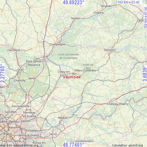
Vaumoise GPS coordinates[2]
49° 14' 6.9" North, 2° 58' 50.772" East
| Map corner | latitude | longitude |
|---|---|---|
| Upper-left | 49.69223°, | 2.27765° |
| Center: | 49.23525°, | 2.98077° |
| Lower-right: | 48.77401°, | 3.6839° |
| Map W x H: | 102.1×102.1 km | = 63.4×63.4mi |
| max Lat: | 51.07786° ⇑15.1% North |
| Vaumoise: | 49.23525° |
| min Lat: | ⇓84.9% South 41.3874° |
| min Long | Vaumoise | max Long |
| -5.08615° | 2.98077° | 9.52242° |
| W 57.5%⇐ | ⇒42.5% E |
Elevation
Elevation of Vaumoise is 106 m = 348 ft, and this is 87.7 m = 288 ft below average elevation for this country.
| Max E: |
2333 m = 7654 ft | 58.7% |
| Avg. | 193.7 m = 635 ft | |
| Vaumoise | 106 m = 348 ft | |
Min E: |
-1 m = -3 ft | 41.3% |
See also: France elevation on elevation.city.
Geographical zone
Vaumoise is located in North temperate zone (between Tropic of Cancer and the Arctic Circle). Distance of this North polar circle is 1926.7 km =1197.2 mi to North.| Distance of | km | miles | from Vaumoise |
|---|---|---|---|
| North Pole | 4532.6 | 2816.4 | to North |
| Arctic Circle | 1926.7 | 1197.2 | to North |
| Tropic Cancer | 2868.5 | 1782.4 | to South |
| Equator | 5474.4 | 3401.6 | to South |


Nearby cities:
15 places around Vaumoise: (largest is in red/bold)
• Betz
9 km =5.6 mi,  191°
191°
• Boissy-Fresnoy
11.3 km =7 mi,  225°
225°
• Bonneuil-en-Valois
5.6 km =3.5 mi,  8°
8°
• Crépy-en-Valois
6.7 km =4.2 mi,  268°
268°
• Fresnoy-la-Rivière
7.2 km =4.5 mi,  320°
320°
• Gilocourt
9.7 km =6 mi,  310°
310°
• Haramont
7.6 km =4.7 mi,  50°
50°
• La Ferté-Milon
12.7 km =7.9 mi,  122°
122°
• Lévignen
6.1 km =3.8 mi, 229°
• Marolles
11.6 km =7.2 mi,  128°
128°
• Morienval
8.2 km =5.1 mi,  327°
327°
• Orrouy
10.9 km =6.8 mi,  304°
304°
• Pierrefonds
12.6 km =7.8 mi,  359°
359°
• Vauciennes
3.6 km =2.2 mi,  89°
89°
• Villers-Cotterêts
8.2 km =5.1 mi,  75°
75°
Sources, notices
• [Note1] Compared only with cities in France existing in our database
• [Src1] Map data: © OpenStreetMap contributors (CC-BY-SA)
• [Src2] Other city data from geonames.org with taken over terms of usage.
• [Src3] Geographical zone / Annual Mean Temperature by Robert A. Rohde @ Wikipedia
