Betz geodata
Betz (Hauts-de-France) is a populated place; located in France in Europe/Paris (GMT+2) time zone. With population of 1,014 people, there are 8739 cities with bigger population in this country. Compared to other cities in France, 83.4% of cities are located further ↓South; 57.2% of cities are located further ←West and 62.4% of cities have higher elevation than Betz. Note1
Administrative division(s):
- Level 1: Hauts-de-France
- Level 2: Département de l'Oise
- Level 3: Arrondissement de Senlis
- Level 4: Betz


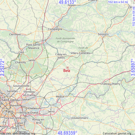
Betz GPS coordinates[2]
49° 9' 20.088" North, 2° 57' 21.024" East
| Map corner | latitude | longitude |
|---|---|---|
| Upper-left | 49.6133°, | 2.25272° |
| Center: | 49.15558°, | 2.95584° |
| Lower-right: | 48.69359°, | 3.65897° |
| Map W x H: | 102.3×102.3 km | = 63.6×63.6mi |
| max Lat: | 51.07786° ⇑16.6% North |
| Betz: | 49.15558° |
| min Lat: | ⇓83.4% South 41.3874° |
| min Long | Betz | max Long |
| -5.08615° | 2.95584° | 9.52242° |
| W 57.2%⇐ | ⇒42.8% E |
Elevation
Elevation of Betz is 96 m = 315 ft, and this is 97.7 m = 321 ft below average elevation for this country.
| Max E: |
2333 m = 7654 ft | 62.4% |
| Avg. | 193.7 m = 635 ft | |
| Betz | 96 m = 315 ft | |
Min E: |
-1 m = -3 ft | 37.6% |
See also: France elevation on elevation.city.
Geographical zone
Betz is located in North temperate zone (between Tropic of Cancer and the Arctic Circle). Distance of this North polar circle is 1935.6 km =1202.7 mi to North.| Distance of | km | miles | from Betz |
|---|---|---|---|
| North Pole | 4541.5 | 2822 | to North |
| Arctic Circle | 1935.6 | 1202.7 | to North |
| Tropic Cancer | 2859.7 | 1776.9 | to South |
| Equator | 5465.6 | 3396.2 | to South |


Nearby cities:
15 places around Betz: (largest is in red/bold)
• Acy-en-Multien
5.7 km =3.5 mi,  180°
180°
• Boissy-Fresnoy
6.3 km =3.9 mi,  278°
278°
• Brégy
10.5 km =6.5 mi,  218°
218°
• Crouy-sur-Ourcq
11.4 km =7.1 mi,  130°
130°
• Crépy-en-Valois
10 km =6.2 mi,  330°
330°
• La Ferté-Milon
12.8 km =8 mi,  80°
80°
• Lévignen
5.7 km =3.5 mi, 330°
• Mareuil-sur-Ourcq
9.1 km =5.7 mi,  102°
102°
• Marolles
11 km =6.8 mi, 81°
• May-en-Multien
10.5 km =6.5 mi,  152°
152°
• Nanteuil-le-Haudouin
10.6 km =6.6 mi,  261°
261°
• Péroy-les-Gombries
8.1 km =5 mi, 275°
• Rouvres-en-Multien
7.1 km =4.4 mi, 127°
• Vauciennes
10.4 km =6.5 mi,  31°
31°
• Vaumoise
9 km =5.6 mi,  11°
11°
Sources, notices
• [Note1] Compared only with cities in France existing in our database
• [Src1] Map data: © OpenStreetMap contributors (CC-BY-SA)
• [Src2] Other city data from geonames.org with taken over terms of usage.
• [Src3] Geographical zone / Annual Mean Temperature by Robert A. Rohde @ Wikipedia
