Épretot geodata
Épretot (Normandy) is a populated place; located in France in Europe/Paris (GMT+2) time zone. With population of 660 people, there are 12381 cities with bigger population in this country. Compared to other cities in France, 89.9% of cities are located further ↓South; 75.2% of cities are located further →East and 56.2% of cities have higher elevation than Épretot. Note1
Administrative division(s):
- Level 1: Normandy
- Level 2: Seine-Maritime
- Level 3: Arrondissement du Havre
- Level 4: Épretot


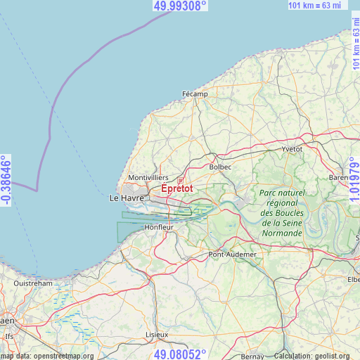
Épretot GPS coordinates[2]
49° 32' 20.148" North, 0° 19' 0.012" East
| Map corner | latitude | longitude |
|---|---|---|
| Upper-left | 49.99308°, | -0.38646° |
| Center: | 49.53893°, | 0.31667° |
| Lower-right: | 49.08052°, | 1.01979° |
| Map W x H: | 101.5×101.5 km | = 63.1×63.1mi |
| max Lat: | 51.07786° ⇑10.1% North |
| Épretot: | 49.53893° |
| min Lat: | ⇓89.9% South 41.3874° |
| min Long | Épretot | max Long |
| -5.08615° | 0.31667° | 9.52242° |
| W 24.8%⇐ | ⇒75.2% E |
Elevation
Elevation of Épretot is 113 m = 371 ft, and this is 80.7 m = 265 ft below average elevation for this country.
| Max E: |
2333 m = 7654 ft | 56.2% |
| Avg. | 193.7 m = 635 ft | |
| Épretot | 113 m = 371 ft | |
Min E: |
-1 m = -3 ft | 43.8% |
See also: France elevation on elevation.city.
Geographical zone
Épretot is located in North temperate zone (between Tropic of Cancer and the Arctic Circle). Distance of this North polar circle is 1893 km =1176.3 mi to North.| Distance of | km | miles | from Épretot |
|---|---|---|---|
| North Pole | 4498.8 | 2795.4 | to North |
| Arctic Circle | 1893 | 1176.3 | to North |
| Tropic Cancer | 2902.3 | 1803.4 | to South |
| Equator | 5508.2 | 3422.6 | to South |


Nearby cities:
15 places around Épretot: (largest is in red/bold)
• Angerville-l’Orcher
6 km =3.7 mi,  335°
335°
• Gainneville
4.6 km =2.9 mi,  240°
240°
• Gommerville
4.2 km =2.6 mi,  62°
62°
• Graimbouville
4.2 km =2.6 mi,  15°
15°
• Manéglise
5.3 km =3.3 mi,  304°
304°
• Rogerville
5.5 km =3.4 mi,  222°
222°
• Sainneville
2.8 km =1.7 mi,  312°
312°
• Saint-Aubin-Routot
1.9 km =1.2 mi,  158°
158°
• Saint-Gilles-de-la-Neuville
5.8 km =3.6 mi,  46°
46°
• Saint-Laurent-de-Brévedent
4.7 km =2.9 mi,  251°
251°
• Saint-Martin-du-Manoir
5.8 km =3.6 mi,  262°
262°
• Saint-Romain-de-Colbosc
3.1 km =1.9 mi,  106°
106°
• Saint-Vincent-Cramesnil
5.1 km =3.2 mi,  141°
141°
• Sandouville
4.6 km =2.9 mi,  179°
179°
• Étainhus
3.1 km =1.9 mi,  354°
354°
Sources, notices
• [Note1] Compared only with cities in France existing in our database
• [Src1] Map data: © OpenStreetMap contributors (CC-BY-SA)
• [Src2] Other city data from geonames.org with taken over terms of usage.
• [Src3] Geographical zone / Annual Mean Temperature by Robert A. Rohde @ Wikipedia
