Ygrande geodata
Ygrande (Auvergne-Rhône-Alpes) is a populated place; located in France in Europe/Paris (GMT+2) time zone. With population of 748 people, there are 11184 cities with bigger population in this country. Compared to other cities in France, 59.7% of cities are located further ↑North; 57% of cities are located further ←West and 83% of cities have lower elevation than Ygrande. Note1
Administrative division(s):
- Level 1: Auvergne-Rhône-Alpes
- Level 2: Département de l'Allier
- Level 3: Arrondissement de Moulins
- Level 4: Ygrande


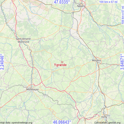
Ygrande GPS coordinates[2]
46° 33' 7.632" North, 2° 56' 36.888" East
| Map corner | latitude | longitude |
|---|---|---|
| Upper-left | 47.0335°, | 2.24046° |
| Center: | 46.55212°, | 2.94358° |
| Lower-right: | 46.06643°, | 3.64671° |
| Map W x H: | 107.5×107.5 km | = 66.8×66.8mi |
| max Lat: | 51.07786° ⇑59.7% North |
| Ygrande: | 46.55212° |
| min Lat: | ⇓40.3% South 41.3874° |
| min Long | Ygrande | max Long |
| -5.08615° | 2.94358° | 9.52242° |
| W 57%⇐ | ⇒43% E |
Elevation
Elevation of Ygrande is 321 m = 1053 ft, and this is 127.3 m = 418 ft above average elevation for this country.
| Max E: |
2333 m = 7654 ft | 17% |
| Ygrande | 321 m 1053 ft | |
| Avg. | 193.7 m = 635 ft | |
Min E: |
-1 m = -3 ft | 83% |
See also: France elevation on elevation.city.
Geographical zone
Ygrande is located in North temperate zone (between Tropic of Cancer and the Arctic Circle). Distance of this North polar circle is 2225.1 km =1382.6 mi to North.| Distance of | km | miles | from Ygrande |
|---|---|---|---|
| North Pole | 4831 | 3001.8 | to North |
| Arctic Circle | 2225.1 | 1382.6 | to North |
| Tropic Cancer | 2570.2 | 1597 | to South |
| Equator | 5176.1 | 3216.3 | to South |


Nearby cities:
15 places around Ygrande: (largest is in red/bold)
• Bourbon-l’Archambault
9.3 km =5.8 mi,  68°
68°
• Buxières-les-Mines
9.4 km =5.8 mi,  172°
172°
• Couleuvre
13.6 km =8.5 mi,  348°
348°
• Cressanges
20.4 km =12.7 mi,  125°
125°
• Cérilly
11.9 km =7.4 mi,  307°
307°
• Hérisson
18.4 km =11.4 mi,  254°
254°
• Le Montet
18.1 km =11.2 mi,  151°
151°
• Lurcy-Lévis
19.8 km =12.3 mi,  358°
358°
• Noyant-d’Allier
15.9 km =9.9 mi,  120°
120°
• Saint-Bonnet-Tronçais
22.6 km =14 mi,  302°
302°
• Saint-Hilaire
8.7 km =5.4 mi,  137°
137°
• Saint-Menoux
17 km =10.6 mi,  77°
77°
• Souvigny
19.1 km =11.9 mi,  95°
95°
• Tronget
17.3 km =10.7 mi, 146°
• Villefranche-d’Allier
18.5 km =11.5 mi,  200°
200°
Sources, notices
• [Note1] Compared only with cities in France existing in our database
• [Src1] Map data: © OpenStreetMap contributors (CC-BY-SA)
• [Src2] Other city data from geonames.org with taken over terms of usage.
• [Src3] Geographical zone / Annual Mean Temperature by Robert A. Rohde @ Wikipedia
