Luché-Pringé geodata
Luché-Pringé (Pays de la Loire) is a populated place; located in France in Europe/Paris (GMT+2) time zone. With population of 1,613 people, there are 5794 cities with bigger population in this country. Compared to other cities in France, 54.3% of cities are located further ↓South; 77.5% of cities are located further →East and 84.5% of cities have higher elevation than Luché-Pringé. Note1
Administrative division(s):
- Level 1: Pays de la Loire
- Level 2: Sarthe
- Level 3: Arrondissement de La Flèche
- Level 4: Luché-Pringé


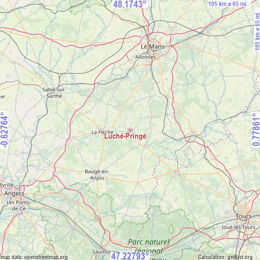
Luché-Pringé GPS coordinates[2]
47° 42' 11.736" North, 0° 4' 31.764" East
| Map corner | latitude | longitude |
|---|---|---|
| Upper-left | 48.1743°, | -0.62764° |
| Center: | 47.70326°, | 0.07549° |
| Lower-right: | 47.22793°, | 0.77861° |
| Map W x H: | 105.2×105.2 km | = 65.4×65.4mi |
| max Lat: | 51.07786° ⇑45.7% North |
| Luché-Pringé: | 47.70326° |
| min Lat: | ⇓54.3% South 41.3874° |
| min Long | Luché-Pringé | max Long |
| -5.08615° | 0.07549° | 9.52242° |
| W 22.5%⇐ | ⇒77.5% E |
Elevation
Elevation of Luché-Pringé is 43 m = 141 ft, and this is 150.7 m = 494 ft below average elevation for this country.
| Max E: |
2333 m = 7654 ft | 84.5% |
| Avg. | 193.7 m = 635 ft | |
| Luché-Pringé | 43 m = 141 ft | |
Min E: |
-1 m = -3 ft | 15.5% |
See also: France elevation on elevation.city.
Geographical zone
Luché-Pringé is located in North temperate zone (between Tropic of Cancer and the Arctic Circle). Distance of this North polar circle is 2097.1 km =1303.1 mi to North.| Distance of | km | miles | from Luché-Pringé |
|---|---|---|---|
| North Pole | 4703 | 2922.3 | to North |
| Arctic Circle | 2097.1 | 1303.1 | to North |
| Tropic Cancer | 2698.2 | 1676.6 | to South |
| Equator | 5304.1 | 3295.8 | to South |


Nearby cities:
15 places around Luché-Pringé: (largest is in red/bold)
• Clefs-Val d'Anjou
14 km =8.7 mi,  231°
231°
• Clermont-Créans
6.9 km =4.3 mi,  283°
283°
• Coulongé
9.6 km =6 mi,  99°
99°
• Cérans-Foulletourte
13.7 km =8.5 mi,  0°
0°
• Dissé-sous-le-Lude
12 km =7.5 mi,  150°
150°
• La Flèche
11.3 km =7 mi,  267°
267°
• Le Lude
8.8 km =5.5 mi,  136°
136°
• Mansigné
6.6 km =4.1 mi,  40°
40°
• Mareil-sur-Loir
5 km =3.1 mi, 284°
• Oizé
12.1 km =7.5 mi,  10°
10°
• Pontvallain
10.2 km =6.3 mi,  58°
58°
• Requeil
11 km =6.8 mi, 35°
• Saint-Jean-de-la-Motte
4.7 km =2.9 mi,  343°
343°
• Thorée-les-Pins
3.1 km =1.9 mi, 234°
• Yvré-le-Pôlin
14.5 km =9 mi,  24°
24°
Sources, notices
• [Note1] Compared only with cities in France existing in our database
• [Src1] Map data: © OpenStreetMap contributors (CC-BY-SA)
• [Src2] Other city data from geonames.org with taken over terms of usage.
• [Src3] Geographical zone / Annual Mean Temperature by Robert A. Rohde @ Wikipedia
