Bourgogne geodata
Bourgogne (Grand Est) is a populated place; located in France in Europe/Paris (GMT+2) time zone. With population of 1,018 people, there are 8707 cities with bigger population in this country. Compared to other cities in France, 87% of cities are located further ↓South; 68.5% of cities are located further ←West and 64.4% of cities have higher elevation than Bourgogne. Note1
Administrative division(s):
- Level 1: Grand Est
- Level 2: Marne
- Level 3: Arrondissement de Reims
- Level 4: Bourgogne-Fresne


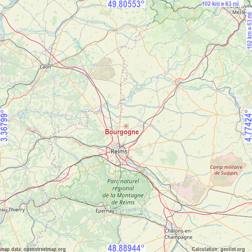
Bourgogne GPS coordinates[2]
49° 20' 58.632" North, 4° 4' 15.996" East
| Map corner | latitude | longitude |
|---|---|---|
| Upper-left | 49.80553°, | 3.36799° |
| Center: | 49.34962°, | 4.07111° |
| Lower-right: | 48.88944°, | 4.77424° |
| Map W x H: | 101.9×101.9 km | = 63.3×63.3mi |
| max Lat: | 51.07786° ⇑13% North |
| Bourgogne: | 49.34962° |
| min Lat: | ⇓87% South 41.3874° |
| min Long | Bourgogne | max Long |
| -5.08615° | 4.07111° | 9.52242° |
| W 68.5%⇐ | ⇒31.5% E |
Elevation
Elevation of Bourgogne is 91 m = 299 ft, and this is 102.7 m = 337 ft below average elevation for this country.
| Max E: |
2333 m = 7654 ft | 64.4% |
| Avg. | 193.7 m = 635 ft | |
| Bourgogne | 91 m = 299 ft | |
Min E: |
-1 m = -3 ft | 35.6% |
See also: France elevation on elevation.city.
Geographical zone
Bourgogne is located in North temperate zone (between Tropic of Cancer and the Arctic Circle). Distance of this North polar circle is 1914 km =1189.3 mi to North.| Distance of | km | miles | from Bourgogne |
|---|---|---|---|
| North Pole | 4519.9 | 2808.5 | to North |
| Arctic Circle | 1914 | 1189.3 | to North |
| Tropic Cancer | 2881.2 | 1790.3 | to South |
| Equator | 5487.2 | 3409.6 | to South |


Nearby cities:
15 places around Bourgogne: (largest is in red/bold)
• Auménancourt-le-Petit
3.1 km =1.9 mi,  344°
344°
• Bazancourt
7.4 km =4.6 mi,  76°
76°
• Boult-sur-Suippe
6 km =3.7 mi,  65°
65°
• Bétheny
7.3 km =4.5 mi,  189°
189°
• Caurel
7.8 km =4.8 mi,  130°
130°
• Cernay-lès-Reims
9.8 km =6.1 mi,  166°
166°
• Courcy
5.7 km =3.5 mi,  239°
239°
• Isles-sur-Suippe
9.4 km =5.8 mi,  85°
85°
• Loivre
6.6 km =4.1 mi,  266°
266°
• Merfy
10.6 km =6.6 mi, 235°
• Neufchâtel-sur-Aisne
9.5 km =5.9 mi, 343°
• Reims
9.9 km =6.2 mi,  198°
198°
• Saint-Thierry
9.1 km =5.7 mi, 237°
• Warmeriville
10.7 km =6.6 mi, 88°
• Witry-lès-Reims
7.3 km =4.5 mi,  151°
151°
Sources, notices
• [Note1] Compared only with cities in France existing in our database
• [Src1] Map data: © OpenStreetMap contributors (CC-BY-SA)
• [Src2] Other city data from geonames.org with taken over terms of usage.
• [Src3] Geographical zone / Annual Mean Temperature by Robert A. Rohde @ Wikipedia
