Liernais geodata
Liernais (Bourgogne-Franche-Comté) is a populated place; located in France in Europe/Paris (GMT+2) time zone. With population of 704 people, there are 11748 cities with bigger population in this country. Compared to other cities in France, 52.9% of cities are located further ↑North; 70.4% of cities are located further ←West and 92.4% of cities have lower elevation than Liernais. Note1
Administrative division(s):
- Level 1: Bourgogne-Franche-Comté
- Level 2: Département de la Côte-d'Or
- Level 3: Arrondissement de Beaune
- Level 4: Liernais


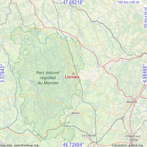
Liernais GPS coordinates[2]
47° 12' 23.976" North, 4° 16' 53.58" East
| Map corner | latitude | longitude |
|---|---|---|
| Upper-left | 47.68218°, | 3.57843° |
| Center: | 47.20666°, | 4.28155° |
| Lower-right: | 46.72684°, | 4.98468° |
| Map W x H: | 106.2×106.2 km | = 66×66mi |
| max Lat: | 51.07786° ⇑52.9% North |
| Liernais: | 47.20666° |
| min Lat: | ⇓47.1% South 41.3874° |
| min Long | Liernais | max Long |
| -5.08615° | 4.28155° | 9.52242° |
| W 70.4%⇐ | ⇒29.6% E |
Elevation
Elevation of Liernais is 487 m = 1598 ft, and this is 293.3 m = 962 ft above average elevation for this country.
| Max E: |
2333 m = 7654 ft | 7.6% |
| Liernais | 487 m 1598 ft | |
| Avg. | 193.7 m = 635 ft | |
Min E: |
-1 m = -3 ft | 92.4% |
See also: France elevation on elevation.city.
Geographical zone
Liernais is located in North temperate zone (between Tropic of Cancer and the Arctic Circle). Distance of this North polar circle is 2152.3 km =1337.4 mi to North.| Distance of | km | miles | from Liernais |
|---|---|---|---|
| North Pole | 4758.2 | 2956.6 | to North |
| Arctic Circle | 2152.3 | 1337.4 | to North |
| Tropic Cancer | 2643 | 1642.3 | to South |
| Equator | 5248.9 | 3261.5 | to South |


Nearby cities:
15 places around Liernais: (largest is in red/bold)
• Alligny-en-Morvan
7.9 km =4.9 mi,  264°
264°
• Anost
19.9 km =12.4 mi,  223°
223°
• Arnay-le-Duc
17.5 km =10.9 mi,  118°
118°
• Dracy-Saint-Loup
21.7 km =13.5 mi,  167°
167°
• Igornay
19.3 km =12 mi,  157°
157°
• La Roche-en-Brenil
20.9 km =13 mi,  338°
338°
• Lacanche
25.6 km =15.9 mi, 124°
• Montsauche-les-Settons
20 km =12.4 mi,  273°
273°
• Ouroux-en-Morvan
25.2 km =15.7 mi, 264°
• Pouilly-en-Auxois
21.6 km =13.4 mi,  73°
73°
• Précy-sous-Thil
20.5 km =12.7 mi,  5°
5°
• Saint-Forgeot
22.6 km =14 mi,  176°
176°
• Saint-Léger-du-Bois
24.8 km =15.4 mi,  149°
149°
• Saulieu
9.1 km =5.7 mi,  333°
333°
• Tavernay
21.7 km =13.5 mi,  189°
189°
Sources, notices
• [Note1] Compared only with cities in France existing in our database
• [Src1] Map data: © OpenStreetMap contributors (CC-BY-SA)
• [Src2] Other city data from geonames.org with taken over terms of usage.
• [Src3] Geographical zone / Annual Mean Temperature by Robert A. Rohde @ Wikipedia
