Saint-Gilles-de-la-Neuville geodata
Saint-Gilles-de-la-Neuville (Normandy) is a populated place; located in France in Europe/Paris (GMT+2) time zone. With population of 577 people, there are 13707 cities with bigger population in this country. Compared to other cities in France, 90.3% of cities are located further ↓South; 74.5% of cities are located further →East and 58.3% of cities have higher elevation than Saint-Gilles-de-la-Neuville. Note1
Administrative division(s):
- Level 1: Normandy
- Level 2: Seine-Maritime
- Level 3: Arrondissement du Havre
- Level 4: Saint-Gilles-de-la-Neuville
Current local time in Saint-Gilles-de-la-Neuville:
05:54 AM, WednesdayDifference from your time zone: hours


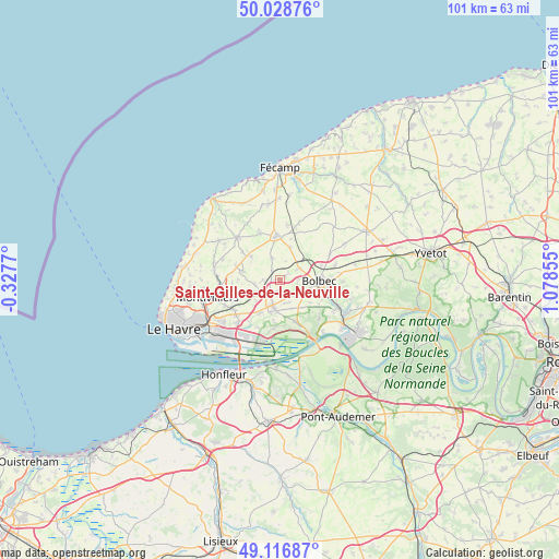
Saint-Gilles-de-la-Neuville GPS coordinates[2]
49° 34' 29.784" North, 0° 22' 31.548" East
| Map corner | latitude | longitude |
|---|---|---|
| Upper-left | 50.02876°, | -0.3277° |
| Center: | 49.57494°, | 0.37543° |
| Lower-right: | 49.11687°, | 1.07855° |
| Map W x H: | 101.4×101.4 km | = 63×63mi |
| max Lat: | 51.07786° ⇑9.7% North |
| Saint-Gilles-de-la-Neuville: | 49.57494° |
| min Lat: | ⇓90.3% South 41.3874° |
| min Long | Saint-Gilles-de | max Long |
| -5.08615° | 0.37543° | 9.52242° |
| W 25.5%⇐ | ⇒74.5% E |
Elevation
Elevation of Saint-Gilles-de-la-Neuville is 107 m = 351 ft, and this is 86.7 m = 284 ft below average elevation for this country.
| Max E: |
2333 m = 7654 ft | 58.3% |
| Avg. | 193.7 m = 635 ft | |
| Saint-Gilles-de-la-Neuville | 107 m = 351 ft | |
Min E: |
-1 m = -3 ft | 41.7% |
See also: France elevation on elevation.city.
Geographical zone
Saint-Gilles-de-la-Neuville is located in North temperate zone (between Tropic of Cancer and the Arctic Circle). Distance of this North polar circle is 1889 km =1173.8 mi to North.| Distance of | km | miles | from Saint-Gilles-de-la-Neuville |
|---|---|---|---|
| North Pole | 4494.8 | 2792.9 | to North |
| Arctic Circle | 1889 | 1173.8 | to North |
| Tropic Cancer | 2906.3 | 1805.9 | to South |
| Equator | 5512.2 | 3425.1 | to South |


Nearby cities:
15 places around Saint-Gilles-de-la-Neuville: (largest is in red/bold)
• Angerville-l’Orcher
6.9 km =4.3 mi,  282°
282°
• Beuzeville-la-Grenier
4.1 km =2.5 mi,  63°
63°
• Bolbec
7.1 km =4.4 mi,  91°
91°
• Bréauté
6.2 km =3.9 mi,  16°
16°
• Gommerville
2.2 km =1.4 mi,  193°
193°
• Graimbouville
3.1 km =1.9 mi,  271°
271°
• La Remuée
5.6 km =3.5 mi,  159°
159°
• Les Trois-Pierres
4.1 km =2.5 mi,  132°
132°
• Manneville-la-Goupil
4.2 km =2.6 mi,  339°
339°
• Sainneville
6.6 km =4.1 mi,  251°
251°
• Saint-Aubin-Routot
6.7 km =4.2 mi,  211°
211°
• Saint-Eustache-la-Forêt
6.4 km =4 mi,  114°
114°
• Saint-Romain-de-Colbosc
5.1 km =3.2 mi,  195°
195°
• Épretot
5.8 km =3.6 mi,  226°
226°
• Étainhus
4.6 km =2.9 mi,  258°
258°
Sources, notices
• [Note1] Compared only with cities in France existing in our database
• [Src1] Map data: © OpenStreetMap contributors (CC-BY-SA)
• [Src2] Other city data from geonames.org with taken over terms of usage.
• [Src3] Geographical zone / Annual Mean Temperature by Robert A. Rohde @ Wikipedia
