Gommerville geodata
Gommerville (Normandy) is a populated place; located in France in Europe/Paris (GMT+2) time zone. With population of 667 people, there are 12267 cities with bigger population in this country. Compared to other cities in France, 90.1% of cities are located further ↓South; 74.6% of cities are located further →East and 51.2% of cities have higher elevation than Gommerville. Note1
Administrative division(s):
- Level 1: Normandy
- Level 2: Seine-Maritime
- Level 3: Arrondissement du Havre
- Level 4: Gommerville


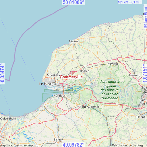
Gommerville GPS coordinates[2]
49° 33' 21.852" North, 0° 22' 6.204" East
| Map corner | latitude | longitude |
|---|---|---|
| Upper-left | 50.01006°, | -0.33474° |
| Center: | 49.55607°, | 0.36839° |
| Lower-right: | 49.09782°, | 1.07151° |
| Map W x H: | 101.4×101.4 km | = 63×63mi |
| max Lat: | 51.07786° ⇑9.9% North |
| Gommerville: | 49.55607° |
| min Lat: | ⇓90.1% South 41.3874° |
| min Long | Gommerville | max Long |
| -5.08615° | 0.36839° | 9.52242° |
| W 25.4%⇐ | ⇒74.6% E |
Elevation
Elevation of Gommerville is 128 m = 420 ft, and this is 65.7 m = 216 ft below average elevation for this country.
| Max E: |
2333 m = 7654 ft | 51.2% |
| Avg. | 193.7 m = 635 ft | |
| Gommerville | 128 m = 420 ft | |
Min E: |
-1 m = -3 ft | 48.8% |
See also: France elevation on elevation.city.
Geographical zone
Gommerville is located in North temperate zone (between Tropic of Cancer and the Arctic Circle). Distance of this North polar circle is 1891.1 km =1175.1 mi to North.| Distance of | km | miles | from Gommerville |
|---|---|---|---|
| North Pole | 4496.9 | 2794.2 | to North |
| Arctic Circle | 1891.1 | 1175.1 | to North |
| Tropic Cancer | 2904.2 | 1804.6 | to South |
| Equator | 5510.1 | 3423.8 | to South |


Nearby cities:
15 places around Gommerville: (largest is in red/bold)
• Beuzeville-la-Grenier
5.8 km =3.6 mi,  46°
46°
• Graimbouville
3.4 km =2.1 mi,  309°
309°
• La Cerlangue
6.5 km =4 mi,  149°
149°
• La Remuée
4 km =2.5 mi,  141°
141°
• Les Trois-Pierres
3.5 km =2.2 mi,  100°
100°
• Manneville-la-Goupil
6.1 km =3.8 mi,  350°
350°
• Mélamare
6.6 km =4.1 mi,  108°
108°
• Sainneville
5.8 km =3.6 mi,  269°
269°
• Saint-Aubin-Routot
4.7 km =2.9 mi,  220°
220°
• Saint-Eustache-la-Forêt
6.3 km =3.9 mi,  94°
94°
• Saint-Gilles-de-la-Neuville
2.2 km =1.4 mi,  13°
13°
• Saint-Romain-de-Colbosc
2.9 km =1.8 mi,  196°
196°
• Saint-Vincent-Cramesnil
6 km =3.7 mi,  185°
185°
• Épretot
4.2 km =2.6 mi,  242°
242°
• Étainhus
4.2 km =2.6 mi,  286°
286°
Sources, notices
• [Note1] Compared only with cities in France existing in our database
• [Src1] Map data: © OpenStreetMap contributors (CC-BY-SA)
• [Src2] Other city data from geonames.org with taken over terms of usage.
• [Src3] Geographical zone / Annual Mean Temperature by Robert A. Rohde @ Wikipedia
