Petit-Couronne geodata
Petit-Couronne (Normandy) is a populated place; located in France in Europe/Paris (GMT+2) time zone. With population of 8,761 people, there are 1094 cities with bigger population in this country. Compared to other cities in France, 87.6% of cities are located further ↓South; 68.6% of cities are located further →East and 98.6% of cities have higher elevation than Petit-Couronne. Note1
Administrative division(s):
- Level 1: Normandy
- Level 2: Seine-Maritime
- Level 3: Arrondissement de Rouen
- Level 4: Petit-Couronne


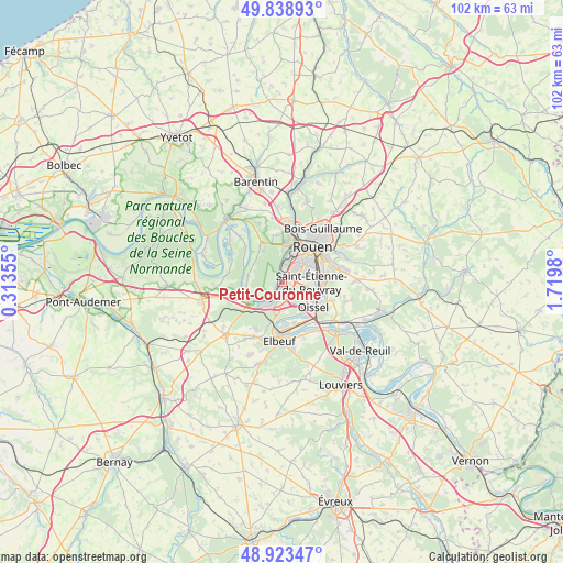
Petit-Couronne GPS coordinates[2]
49° 22' 59.988" North, 1° 1' 0.012" East
| Map corner | latitude | longitude |
|---|---|---|
| Upper-left | 49.83893°, | 0.31355° |
| Center: | 49.38333°, | 1.01667° |
| Lower-right: | 48.92347°, | 1.7198° |
| Map W x H: | 101.8×101.8 km | = 63.3×63.3mi |
| max Lat: | 51.07786° ⇑12.4% North |
| Petit-Couronne: | 49.38333° |
| min Lat: | ⇓87.6% South 41.3874° |
| min Long | Petit-Couronne | max Long |
| -5.08615° | 1.01667° | 9.52242° |
| W 31.4%⇐ | ⇒68.6% E |
Elevation
Elevation of Petit-Couronne is 7 m = 23 ft, and this is 186.7 m = 613 ft below average elevation for this country.
| Max E: |
2333 m = 7654 ft | 98.6% |
| Avg. | 193.7 m = 635 ft | |
| Petit-Couronne | 7 m = 23 ft | |
Min E: |
-1 m = -3 ft | 1.4% |
See also: France elevation on elevation.city.
Geographical zone
Petit-Couronne is located in North temperate zone (between Tropic of Cancer and the Arctic Circle). Distance of this North polar circle is 1910.3 km =1187 mi to North.| Distance of | km | miles | from Petit-Couronne |
|---|---|---|---|
| North Pole | 4516.2 | 2806.2 | to North |
| Arctic Circle | 1910.3 | 1187 | to North |
| Tropic Cancer | 2885 | 1792.7 | to South |
| Equator | 5490.9 | 3411.9 | to South |


Nearby cities:
15 places around Petit-Couronne: (largest is in red/bold)
• Canteleu
6.4 km =4 mi,  5°
5°
• Cléon
7.9 km =4.9 mi,  173°
173°
• Grand-Couronne
3.2 km =2 mi,  193°
193°
• La Bouille
7.1 km =4.4 mi,  238°
238°
• Le Grand-Quevilly
2.9 km =1.8 mi,  47°
47°
• Le Petit-Quevilly
4.7 km =2.9 mi,  44°
44°
• Moulineaux
6.1 km =3.8 mi,  223°
223°
• Oissel
7.9 km =4.9 mi,  134°
134°
• Quevillon
6.1 km =3.8 mi,  311°
311°
• Sahurs
6 km =3.7 mi, 242°
• Saint-Martin-de-Boscherville
7.8 km =4.8 mi,  329°
329°
• Saint-Pierre-de-Manneville
6.1 km =3.8 mi,  280°
280°
• Saint-Étienne-du-Rouvray
6.4 km =4 mi,  95°
95°
• Sotteville-lès-Rouen
6.1 km =3.8 mi,  61°
61°
• Val-de-la-Haye
1.2 km =0.7 mi, 243°
Sources, notices
• [Note1] Compared only with cities in France existing in our database
• [Src1] Map data: © OpenStreetMap contributors (CC-BY-SA)
• [Src2] Other city data from geonames.org with taken over terms of usage.
• [Src3] Geographical zone / Annual Mean Temperature by Robert A. Rohde @ Wikipedia
