Le Mesnil-Aubry geodata
Le Mesnil-Aubry (Île-de-France) is a populated place; located in France in Europe/Paris (GMT+2) time zone. With population of 962 people, there are 9112 cities with bigger population in this country. Compared to other cities in France, 81% of cities are located further ↓South; 51.1% of cities are located further →East and 56.2% of cities have higher elevation than Le Mesnil-Aubry. Note1
Administrative division(s):
- Level 1: Île-de-France
- Level 2: Département du Val-d’Oise
- Level 3: Arrondissement de Sarcelles
- Level 4: Le Mesnil-Aubry


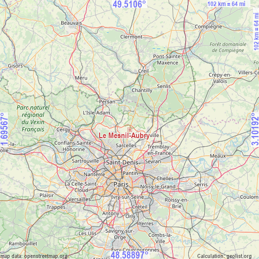
Le Mesnil-Aubry GPS coordinates[2]
49° 3' 6.912" North, 2° 23' 55.68" East
| Map corner | latitude | longitude |
|---|---|---|
| Upper-left | 49.5106°, | 1.69567° |
| Center: | 49.05192°, | 2.3988° |
| Lower-right: | 48.58897°, | 3.10192° |
| Map W x H: | 102.5×102.5 km | = 63.7×63.7mi |
| max Lat: | 51.07786° ⇑19% North |
| Le Mesnil-Aubry: | 49.05192° |
| min Lat: | ⇓81% South 41.3874° |
| min Long | Le Mesnil-Aubry | max Long |
| -5.08615° | 2.3988° | 9.52242° |
| W 48.9%⇐ | ⇒51.1% E |
Elevation
Elevation of Le Mesnil-Aubry is 113 m = 371 ft, and this is 80.7 m = 265 ft below average elevation for this country.
| Max E: |
2333 m = 7654 ft | 56.2% |
| Avg. | 193.7 m = 635 ft | |
| Le Mesnil-Aubry | 113 m = 371 ft | |
Min E: |
-1 m = -3 ft | 43.8% |
See also: France elevation on elevation.city.
Geographical zone
Le Mesnil-Aubry is located in North temperate zone (between Tropic of Cancer and the Arctic Circle). Distance of this North polar circle is 1947.1 km =1209.9 mi to North.| Distance of | km | miles | from Le Mesnil-Aubry |
|---|---|---|---|
| North Pole | 4553 | 2829.1 | to North |
| Arctic Circle | 1947.1 | 1209.9 | to North |
| Tropic Cancer | 2848.1 | 1769.7 | to South |
| Equator | 5454.1 | 3389 | to South |


Nearby cities:
15 places around Le Mesnil-Aubry: (largest is in red/bold)
• Attainville
4 km =2.5 mi,  279°
279°
• Belloy-en-France
4.5 km =2.8 mi,  333°
333°
• Domont
5.9 km =3.7 mi,  243°
243°
• Fontenay-en-Parisis
3.8 km =2.4 mi,  87°
87°
• Goussainville
6.5 km =4 mi,  130°
130°
• Mareil-en-France
2.8 km =1.7 mi,  44°
44°
• Moisselles
4.6 km =2.9 mi,  267°
267°
• Montsoult
6.1 km =3.8 mi,  288°
288°
• Piscop
5.9 km =3.7 mi,  221°
221°
• Saint-Brice-sous-Forêt
6.5 km =4 mi,  210°
210°
• Sarcelles
6.2 km =3.9 mi,  193°
193°
• Villaines-sous-Bois
4 km =2.5 mi,  312°
312°
• Villiers-le-Bel
4.8 km =3 mi,  180°
180°
• Écouen
3.7 km =2.3 mi,  198°
198°
• Ézanville
3.5 km =2.2 mi, 220°
Sources, notices
• [Note1] Compared only with cities in France existing in our database
• [Src1] Map data: © OpenStreetMap contributors (CC-BY-SA)
• [Src2] Other city data from geonames.org with taken over terms of usage.
• [Src3] Geographical zone / Annual Mean Temperature by Robert A. Rohde @ Wikipedia
