Mareil-en-France geodata
Mareil-en-France (Île-de-France) is a populated place; located in France in Europe/Paris (GMT+2) time zone. With population of 587 people, there are 13526 cities with bigger population in this country. Compared to other cities in France, 81.4% of cities are located further ↓South; 50.6% of cities are located further →East and 57.6% of cities have lower elevation than Mareil-en-France. Note1
Administrative division(s):
- Level 1: Île-de-France
- Level 2: Département du Val-d’Oise
- Level 3: Arrondissement de Sarcelles
- Level 4: Mareil-en-France


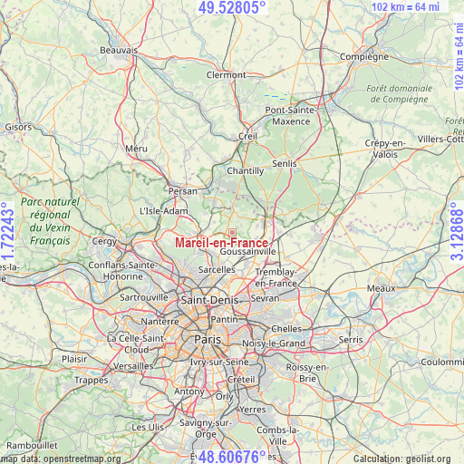
Mareil-en-France GPS coordinates[2]
49° 4' 10.344" North, 2° 25' 31.98" East
| Map corner | latitude | longitude |
|---|---|---|
| Upper-left | 49.52805°, | 1.72243° |
| Center: | 49.06954°, | 2.42555° |
| Lower-right: | 48.60676°, | 3.12868° |
| Map W x H: | 102.4×102.4 km | = 63.6×63.6mi |
| max Lat: | 51.07786° ⇑18.6% North |
| Mareil-en-France: | 49.06954° |
| min Lat: | ⇓81.4% South 41.3874° |
| min Long | Mareil-en-Franc | max Long |
| -5.08615° | 2.42555° | 9.52242° |
| W 49.4%⇐ | ⇒50.6% E |
Elevation
Elevation of Mareil-en-France is 160 m = 525 ft, and this is 33.7 m = 111 ft below average elevation for this country.
| Max E: |
2333 m = 7654 ft | 42.4% |
| Avg. | 193.7 m = 635 ft | |
| Mareil-en-France | 160 m = 525 ft | |
Min E: |
-1 m = -3 ft | 57.6% |
See also: France elevation on elevation.city.
Geographical zone
Mareil-en-France is located in North temperate zone (between Tropic of Cancer and the Arctic Circle). Distance of this North polar circle is 1945.2 km =1208.7 mi to North.| Distance of | km | miles | from Mareil-en-France |
|---|---|---|---|
| North Pole | 4551 | 2827.9 | to North |
| Arctic Circle | 1945.2 | 1208.7 | to North |
| Tropic Cancer | 2850.1 | 1771 | to South |
| Equator | 5456 | 3390.2 | to South |


Nearby cities:
15 places around Mareil-en-France: (largest is in red/bold)
• Attainville
6 km =3.7 mi,  257°
257°
• Bellefontaine
4.3 km =2.7 mi,  43°
43°
• Belloy-en-France
4.5 km =2.8 mi,  298°
298°
• Chaumontel
6.2 km =3.9 mi,  4°
4°
• Fontenay-en-Parisis
2.6 km =1.6 mi,  132°
132°
• Fosses
6.9 km =4.3 mi,  62°
62°
• Le Mesnil-Aubry
2.8 km =1.7 mi,  224°
224°
• Louvres
6.4 km =4 mi,  115°
115°
• Luzarches
4.9 km =3 mi,  357°
357°
• Marly-la-Ville
5.8 km =3.6 mi,  76°
76°
• Puiseux-en-France
5.7 km =3.5 mi,  105°
105°
• Seugy
6.3 km =3.9 mi,  338°
338°
• Villaines-sous-Bois
5 km =3.1 mi,  278°
278°
• Écouen
6.3 km =3.9 mi,  209°
209°
• Ézanville
6.3 km =3.9 mi, 222°
Sources, notices
• [Note1] Compared only with cities in France existing in our database
• [Src1] Map data: © OpenStreetMap contributors (CC-BY-SA)
• [Src2] Other city data from geonames.org with taken over terms of usage.
• [Src3] Geographical zone / Annual Mean Temperature by Robert A. Rohde @ Wikipedia
