Cussay geodata
Cussay (Centre) is a populated place; located in France in Europe/Paris (GMT+2) time zone. With population of 583 people, there are 13590 cities with bigger population in this country. Compared to other cities in France, 55% of cities are located further ↑North; 70.6% of cities are located further →East and 62.8% of cities have higher elevation than Cussay. Note1
Administrative division(s):
- Level 1: Centre
- Level 2: Département d'Indre-et-Loire
- Level 3: Arrondissement de Loches
- Level 4: Cussay


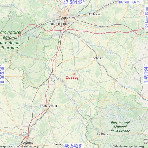
Cussay GPS coordinates[2]
47° 1' 27.336" North, 0° 47' 18.672" East
| Map corner | latitude | longitude |
|---|---|---|
| Upper-left | 47.50142°, | 0.08539° |
| Center: | 47.02426°, | 0.78852° |
| Lower-right: | 46.5428°, | 1.49164° |
| Map W x H: | 106.6×106.6 km | = 66.2×66.2mi |
| max Lat: | 51.07786° ⇑55% North |
| Cussay: | 47.02426° |
| min Lat: | ⇓45% South 41.3874° |
| min Long | Cussay | max Long |
| -5.08615° | 0.78852° | 9.52242° |
| W 29.4%⇐ | ⇒70.6% E |
Elevation
Elevation of Cussay is 95 m = 312 ft, and this is 98.7 m = 324 ft below average elevation for this country.
| Max E: |
2333 m = 7654 ft | 62.8% |
| Avg. | 193.7 m = 635 ft | |
| Cussay | 95 m = 312 ft | |
Min E: |
-1 m = -3 ft | 37.2% |
See also: France elevation on elevation.city.
Geographical zone
Cussay is located in North temperate zone (between Tropic of Cancer and the Arctic Circle). Distance of this North polar circle is 2172.6 km =1350 mi to North.| Distance of | km | miles | from Cussay |
|---|---|---|---|
| North Pole | 4778.5 | 2969.2 | to North |
| Arctic Circle | 2172.6 | 1350 | to North |
| Tropic Cancer | 2622.7 | 1629.7 | to South |
| Equator | 5228.6 | 3248.9 | to South |


Nearby cities:
15 places around Cussay: (largest is in red/bold)
• Abilly
10.9 km =6.8 mi,  202°
202°
• Betz-le-Château
10.6 km =6.6 mi,  110°
110°
• Dangé-Saint-Romain
17.5 km =10.9 mi,  234°
234°
• Descartes
9.3 km =5.8 mi, 226°
• Dolus-le-Sec
17.6 km =10.9 mi,  27°
27°
• Draché
12.8 km =8 mi,  285°
285°
• La Celle-Saint-Avant
13.9 km =8.6 mi,  268°
268°
• La Chapelle-Blanche-Saint-Martin
6.8 km =4.2 mi,  2°
2°
• Le Grand-Pressigny
11.6 km =7.2 mi,  174°
174°
• Les Ormes
15 km =9.3 mi,  247°
247°
• Ligueil
3 km =1.9 mi,  49°
49°
• Maillé
16 km =9.9 mi,  281°
281°
• Manthelan
12.5 km =7.8 mi, 1°
• Port-de-Piles
14.5 km =9 mi,  260°
260°
• Sainte-Maure-de-Touraine
15.9 km =9.9 mi,  307°
307°
Sources, notices
• [Note1] Compared only with cities in France existing in our database
• [Src1] Map data: © OpenStreetMap contributors (CC-BY-SA)
• [Src2] Other city data from geonames.org with taken over terms of usage.
• [Src3] Geographical zone / Annual Mean Temperature by Robert A. Rohde @ Wikipedia
