La Salle-de-Vihiers geodata
La Salle-de-Vihiers (Pays de la Loire) is a populated place; located in France in Europe/Paris (GMT+2) time zone. With population of 971 people, there are 9054 cities with bigger population in this country. Compared to other cities in France, 53.5% of cities are located further ↑North; 84.9% of cities are located further →East and 63.6% of cities have lower elevation than La Salle-de-Vihiers. Note1
Administrative division(s):
- Level 1: Pays de la Loire
- Level 2: Département de Maine-et-Loire
- Level 3: Arrondissement de Cholet
- Level 4: Chemillé-en-Anjou


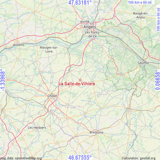
La Salle-de-Vihiers GPS coordinates[2]
47° 9' 20.988" North, 0° 38' 11.58" West
| Map corner | latitude | longitude |
|---|---|---|
| Upper-left | 47.63181°, | -1.33968° |
| Center: | 47.15583°, | -0.63655° |
| Lower-right: | 46.67555°, | 0.06658° |
| Map W x H: | 106.3×106.3 km | = 66.1×66.1mi |
| max Lat: | 51.07786° ⇑53.5% North |
| La Salle-de-Vihiers: | 47.15583° |
| min Lat: | ⇓46.5% South 41.3874° |
| min Long | La Salle-de-Vih | max Long |
| -5.08615° | -0.63655° | 9.52242° |
| W 15.1%⇐ | ⇒84.9% E |
Elevation
Elevation of La Salle-de-Vihiers is 187 m = 614 ft, and this is 6.7 m = 22 ft below average elevation for this country.
| Max E: |
2333 m = 7654 ft | 36.4% |
| Avg. | 193.7 m = 635 ft | |
| La Salle-de-Vihiers | 187 m = 614 ft | |
Min E: |
-1 m = -3 ft | 63.6% |
See also: France elevation on elevation.city.
Geographical zone
La Salle-de-Vihiers is located in North temperate zone (between Tropic of Cancer and the Arctic Circle). Distance of this North polar circle is 2157.9 km =1340.9 mi to North.| Distance of | km | miles | from La Salle-de-Vihiers |
|---|---|---|---|
| North Pole | 4763.8 | 2960.1 | to North |
| Arctic Circle | 2157.9 | 1340.9 | to North |
| Tropic Cancer | 2637.3 | 1638.7 | to South |
| Equator | 5243.2 | 3258 | to South |


Nearby cities:
15 places around La Salle-de-Vihiers: (largest is in red/bold)
• Chanteloup-les-Bois
7.7 km =4.8 mi,  207°
207°
• Chanzeaux
11.9 km =7.4 mi,  357°
357°
• Chemillé-Melay
9.4 km =5.8 mi,  314°
314°
• Coron
3.2 km =2 mi,  191°
191°
• Faveraye-Mâchelles
14.7 km =9.1 mi,  44°
44°
• La Chapelle-Rousselin
13.6 km =8.5 mi,  298°
298°
• La Plaine
9.8 km =6.1 mi,  179°
179°
• La Tourlandry
4.8 km =3 mi,  253°
253°
• Melay
5.3 km =3.3 mi, 305°
• Nuaillé
13.7 km =8.5 mi,  240°
240°
• Saint-Paul-du-Bois
10.9 km =6.8 mi,  140°
140°
• Somloire
13.9 km =8.6 mi,  171°
171°
• Trémentines
11.8 km =7.3 mi, 252°
• Vezins
6.8 km =4.2 mi,  234°
234°
• Vihiers
7.9 km =4.9 mi,  97°
97°
Sources, notices
• [Note1] Compared only with cities in France existing in our database
• [Src1] Map data: © OpenStreetMap contributors (CC-BY-SA)
• [Src2] Other city data from geonames.org with taken over terms of usage.
• [Src3] Geographical zone / Annual Mean Temperature by Robert A. Rohde @ Wikipedia
