Lapugnoy geodata
Lapugnoy (Hauts-de-France) is a populated place; located in France in Europe/Paris (GMT+2) time zone. With population of 3,384 people, there are 2875 cities with bigger population in this country. Compared to other cities in France, 97.5% of cities are located further ↓South; 51.1% of cities are located further ←West and 85.3% of cities have higher elevation than Lapugnoy. Note1
Administrative division(s):
- Level 1: Hauts-de-France
- Level 2: Pas-de-Calais
- Level 3: Arrondissement de Béthune
- Level 4: Lapugnoy


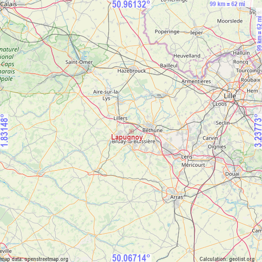
Lapugnoy GPS coordinates[2]
50° 30' 58.86" North, 2° 32' 4.56" East
| Map corner | latitude | longitude |
|---|---|---|
| Upper-left | 50.96132°, | 1.83148° |
| Center: | 50.51635°, | 2.5346° |
| Lower-right: | 50.06714°, | 3.23773° |
| Map W x H: | 99.4×99.4 km | = 61.8×61.8mi |
| max Lat: | 51.07786° ⇑2.5% North |
| Lapugnoy: | 50.51635° |
| min Lat: | ⇓97.5% South 41.3874° |
| min Long | Lapugnoy | max Long |
| -5.08615° | 2.5346° | 9.52242° |
| W 51.1%⇐ | ⇒48.9% E |
Elevation
Elevation of Lapugnoy is 41 m = 135 ft, and this is 152.7 m = 501 ft below average elevation for this country.
| Max E: |
2333 m = 7654 ft | 85.3% |
| Avg. | 193.7 m = 635 ft | |
| Lapugnoy | 41 m = 135 ft | |
Min E: |
-1 m = -3 ft | 14.7% |
See also: France elevation on elevation.city.
Geographical zone
Lapugnoy is located in North temperate zone (between Tropic of Cancer and the Arctic Circle). Distance of this North polar circle is 1784.3 km =1108.7 mi to North.| Distance of | km | miles | from Lapugnoy |
|---|---|---|---|
| North Pole | 4390.2 | 2727.9 | to North |
| Arctic Circle | 1784.3 | 1108.7 | to North |
| Tropic Cancer | 3011 | 1870.9 | to South |
| Equator | 5616.9 | 3490.2 | to South |


Nearby cities:
15 places around Lapugnoy: (largest is in red/bold)
• Allouagne
2.3 km =1.4 mi,  316°
316°
• Auchel
4.6 km =2.9 mi,  251°
251°
• Bruay-la-Buissière
3.8 km =2.4 mi,  163°
163°
• Burbure
5.2 km =3.2 mi,  295°
295°
• Chocques
3.8 km =2.4 mi,  44°
44°
• Divion
5.4 km =3.4 mi,  202°
202°
• Fouquereuil
4.6 km =2.9 mi,  86°
86°
• Fouquières-lès-Béthune
5.3 km =3.3 mi, 91°
• Gosnay
4 km =2.5 mi,  106°
106°
• Haillicourt
5.4 km =3.4 mi,  148°
148°
• Hesdigneul-lès-Béthune
4.2 km =2.6 mi, 112°
• Labeuvrière
2 km =1.2 mi,  81°
81°
• Lozinghem
2.3 km =1.4 mi,  267°
267°
• Marles-les-Mines
2.2 km =1.4 mi,  234°
234°
• Vendin-lès-Béthune
5.4 km =3.4 mi,  60°
60°
Sources, notices
• [Note1] Compared only with cities in France existing in our database
• [Src1] Map data: © OpenStreetMap contributors (CC-BY-SA)
• [Src2] Other city data from geonames.org with taken over terms of usage.
• [Src3] Geographical zone / Annual Mean Temperature by Robert A. Rohde @ Wikipedia
