Ronno geodata
Ronno (Auvergne-Rhône-Alpes) is a populated place; located in France in Europe/Paris (GMT+2) time zone. With population of 640 people, there are 12673 cities with bigger population in this country. Compared to other cities in France, 66.4% of cities are located further ↑North; 71.3% of cities are located further ←West and 93.8% of cities have lower elevation than Ronno. Note1
Administrative division(s):
- Level 1: Auvergne-Rhône-Alpes
- Level 2: Département du Rhône
- Level 3: Arrondissement de Villefranche-sur-Saône
- Level 4: Ronno


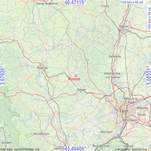
Ronno GPS coordinates[2]
45° 59' 5.208" North, 4° 22' 56.604" East
| Map corner | latitude | longitude |
|---|---|---|
| Upper-left | 46.47119°, | 3.67926° |
| Center: | 45.98478°, | 4.38239° |
| Lower-right: | 45.49406°, | 5.08551° |
| Map W x H: | 108.6×108.6 km | = 67.5×67.5mi |
| max Lat: | 51.07786° ⇑66.4% North |
| Ronno: | 45.98478° |
| min Lat: | ⇓33.6% South 41.3874° |
| min Long | Ronno | max Long |
| -5.08615° | 4.38239° | 9.52242° |
| W 71.3%⇐ | ⇒28.7% E |
Elevation
Elevation of Ronno is 535 m = 1755 ft, and this is 341.3 m = 1120 ft above average elevation for this country.
| Max E: |
2333 m = 7654 ft | 6.2% |
| Ronno | 535 m 1755 ft | |
| Avg. | 193.7 m = 635 ft | |
Min E: |
-1 m = -3 ft | 93.8% |
See also: France elevation on elevation.city.
Geographical zone
Ronno is located in North temperate zone (between Tropic of Cancer and the Arctic Circle). Distance of this North polar circle is 2288.1 km =1421.8 mi to North.| Distance of | km | miles | from Ronno |
|---|---|---|---|
| North Pole | 4894 | 3041 | to North |
| Arctic Circle | 2288.1 | 1421.8 | to North |
| Tropic Cancer | 2507.1 | 1557.8 | to South |
| Equator | 5113 | 3177.1 | to South |


Nearby cities:
15 places around Ronno: (largest is in red/bold)
• Amplepuis
4.2 km =2.6 mi,  251°
251°
• Bourg-de-Thizy
8.4 km =5.2 mi,  310°
310°
• Chambost-Allières
9.7 km =6 mi,  67°
67°
• Chamelet
9.8 km =6.1 mi,  90°
90°
• Cublize
3.7 km =2.3 mi,  354°
354°
• Fourneaux
10 km =6.2 mi,  239°
239°
• Grandris
9.3 km =5.8 mi,  50°
50°
• Les Sauvages
6.7 km =4.2 mi,  183°
183°
• Mardore
10.1 km =6.3 mi,  340°
340°
• Marnand
7 km =4.3 mi,  323°
323°
• Saint-Clément-sur-Valsonne
8.8 km =5.5 mi,  140°
140°
• Saint-Jean-la-Bussière
4.9 km =3 mi,  290°
290°
• Saint-Victor-sur-Rhins
8 km =5 mi, 285°
• Thizy-les-Bourgs
7.3 km =4.5 mi, 313°
• Valsonne
5.6 km =3.5 mi, 139°
Sources, notices
• [Note1] Compared only with cities in France existing in our database
• [Src1] Map data: © OpenStreetMap contributors (CC-BY-SA)
• [Src2] Other city data from geonames.org with taken over terms of usage.
• [Src3] Geographical zone / Annual Mean Temperature by Robert A. Rohde @ Wikipedia
