Trun geodata
Trun (Normandy) is a populated place; located in France in Europe/Paris (GMT+2) time zone. With population of 1,345 people, there are 6839 cities with bigger population in this country. Compared to other cities in France, 76.5% of cities are located further ↓South; 77.9% of cities are located further →East and 68.7% of cities have higher elevation than Trun. Note1
Administrative division(s):
- Level 1: Normandy
- Level 2: Département de l'Orne
- Level 3: Argentan
- Level 4: Trun


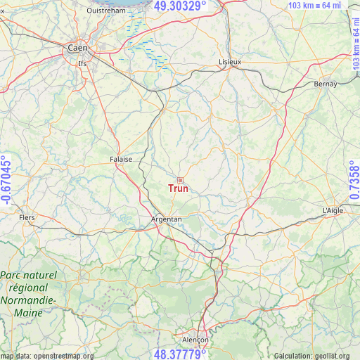
Trun GPS coordinates[2]
48° 50' 33.648" North, 0° 1' 57.648" East
| Map corner | latitude | longitude |
|---|---|---|
| Upper-left | 49.30329°, | -0.67045° |
| Center: | 48.84268°, | 0.03268° |
| Lower-right: | 48.37779°, | 0.7358° |
| Map W x H: | 102.9×102.9 km | = 63.9×63.9mi |
| max Lat: | 51.07786° ⇑23.5% North |
| Trun: | 48.84268° |
| min Lat: | ⇓76.5% South 41.3874° |
| min Long | Trun | max Long |
| -5.08615° | 0.03268° | 9.52242° |
| W 22.1%⇐ | ⇒77.9% E |
Elevation
Elevation of Trun is 81 m = 266 ft, and this is 112.7 m = 370 ft below average elevation for this country.
| Max E: |
2333 m = 7654 ft | 68.7% |
| Avg. | 193.7 m = 635 ft | |
| Trun | 81 m = 266 ft | |
Min E: |
-1 m = -3 ft | 31.3% |
See also: France elevation on elevation.city.
Geographical zone
Trun is located in North temperate zone (between Tropic of Cancer and the Arctic Circle). Distance of this North polar circle is 1970.4 km =1224.3 mi to North.| Distance of | km | miles | from Trun |
|---|---|---|---|
| North Pole | 4576.3 | 2843.6 | to North |
| Arctic Circle | 1970.4 | 1224.3 | to North |
| Tropic Cancer | 2824.9 | 1755.3 | to South |
| Equator | 5430.8 | 3374.5 | to South |


Nearby cities:
15 places around Trun: (largest is in red/bold)
• Almenêches
17.2 km =10.7 mi,  160°
160°
• Argentan
11.6 km =7.2 mi,  199°
199°
• Bailleul
5.4 km =3.4 mi,  209°
209°
• Courteilles
18.6 km =11.6 mi,  246°
246°
• Falaise
17.6 km =10.9 mi,  288°
288°
• La Hoguette
14.8 km =9.2 mi,  284°
284°
• Morteaux-Coulibœuf
12.4 km =7.7 mi,  324°
324°
• Notre-Dame-de-Fresnay
13.4 km =8.3 mi,  3°
3°
• Occagnes
10.3 km =6.4 mi,  227°
227°
• Saint-Pierre-sur-Dives
19.9 km =12.4 mi,  346°
346°
• Sarceaux
14.8 km =9.2 mi, 201°
• Urou-et-Crennes
10 km =6.2 mi,  186°
186°
• Vendeuvre
18.2 km =11.3 mi,  334°
334°
• Vimoutiers
15.4 km =9.6 mi,  52°
52°
• Écouché
18 km =11.2 mi,  219°
219°
Sources, notices
• [Note1] Compared only with cities in France existing in our database
• [Src1] Map data: © OpenStreetMap contributors (CC-BY-SA)
• [Src2] Other city data from geonames.org with taken over terms of usage.
• [Src3] Geographical zone / Annual Mean Temperature by Robert A. Rohde @ Wikipedia
