Lagrasse geodata
Lagrasse (Occitanie) is a populated place; located in France in Europe/Paris (GMT+2) time zone. With population of 671 people, there are 12198 cities with bigger population in this country. Compared to other cities in France, 98% of cities are located further ↑North; 52.3% of cities are located further ←West and 50.5% of cities have higher elevation than Lagrasse. Note1
Administrative division(s):
- Level 1: Occitanie
- Level 2: Département de l'Aude
- Level 3: Arrondissement de Narbonne
- Level 4: Lagrasse


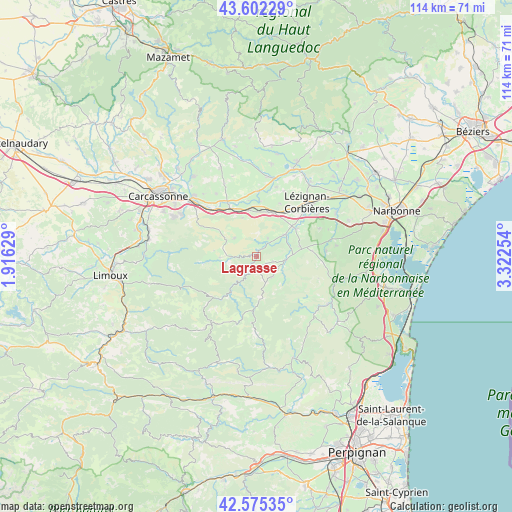
Lagrasse GPS coordinates[2]
43° 5' 27.492" North, 2° 37' 9.912" East
| Map corner | latitude | longitude |
|---|---|---|
| Upper-left | 43.60229°, | 1.91629° |
| Center: | 43.09097°, | 2.61942° |
| Lower-right: | 42.57535°, | 3.32254° |
| Map W x H: | 114.2×114.2 km | = 71×71mi |
| max Lat: | 51.07786° ⇑98% North |
| Lagrasse: | 43.09097° |
| min Lat: | ⇓2% South 41.3874° |
| min Long | Lagrasse | max Long |
| -5.08615° | 2.61942° | 9.52242° |
| W 52.3%⇐ | ⇒47.7% E |
Elevation
Elevation of Lagrasse is 130 m = 427 ft, and this is 63.7 m = 209 ft below average elevation for this country.
| Max E: |
2333 m = 7654 ft | 50.5% |
| Avg. | 193.7 m = 635 ft | |
| Lagrasse | 130 m = 427 ft | |
Min E: |
-1 m = -3 ft | 49.5% |
See also: France elevation on elevation.city.
Geographical zone
Lagrasse is located in North temperate zone (between Tropic of Cancer and the Arctic Circle). Distance of this Northern Tropic circle is 2185.3 km =1357.9 mi to South.| Distance of | km | miles | from Lagrasse |
|---|---|---|---|
| North Pole | 5215.8 | 3240.9 | to North |
| Arctic Circle | 2609.9 | 1621.7 | to North |
| Tropic Cancer | 2185.3 | 1357.9 | to South |
| Equator | 4791.3 | 2977.2 | to South |


Nearby cities:
15 places around Lagrasse: (largest is in red/bold)
• Barbaira
13.6 km =8.5 mi,  320°
320°
• Boutenac
15.3 km =9.5 mi,  65°
65°
• Capendu
11.7 km =7.3 mi,  334°
334°
• Conilhac-Corbières
13.4 km =8.3 mi,  35°
35°
• Douzens
10.5 km =6.5 mi,  351°
351°
• Fabrezan
8.1 km =5 mi,  52°
52°
• Ferrals-les-Corbières
11.3 km =7 mi, 54°
• Luc-sur-Orbieu
16.5 km =10.3 mi, 54°
• Lézignan-Corbières
16.5 km =10.3 mi, 44°
• Marseillette
13.9 km =8.6 mi, 333°
• Montlaur
6.6 km =4.1 mi,  310°
310°
• Moux
10.2 km =6.3 mi,  15°
15°
• Puicheric
14.8 km =9.2 mi,  1°
1°
• Saint-Laurent-de-la-Cabrerisse
6.7 km =4.2 mi,  95°
95°
• Thézan-des-Corbières
12 km =7.5 mi,  85°
85°
Sources, notices
• [Note1] Compared only with cities in France existing in our database
• [Src1] Map data: © OpenStreetMap contributors (CC-BY-SA)
• [Src2] Other city data from geonames.org with taken over terms of usage.
• [Src3] Geographical zone / Annual Mean Temperature by Robert A. Rohde @ Wikipedia
