La Coulonche geodata
La Coulonche (Normandy) is a populated place; located in France in Europe/Paris (GMT+2) time zone. With population of 505 people, there are 15148 cities with bigger population in this country. Compared to other cities in France, 72% of cities are located further ↓South; 82.8% of cities are located further →East and 81.6% of cities have lower elevation than La Coulonche. Note1
Administrative division(s):
- Level 1: Normandy
- Level 2: Département de l'Orne
- Level 3: Argentan
- Level 4: La Coulonche


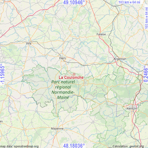
La Coulonche GPS coordinates[2]
48° 38' 49.38" North, 0° 27' 23.508" West
| Map corner | latitude | longitude |
|---|---|---|
| Upper-left | 49.10946°, | -1.15965° |
| Center: | 48.64705°, | -0.45653° |
| Lower-right: | 48.18036°, | 0.2466° |
| Map W x H: | 103.3×103.3 km | = 64.2×64.2mi |
| max Lat: | 51.07786° ⇑28% North |
| La Coulonche: | 48.64705° |
| min Lat: | ⇓72% South 41.3874° |
| min Long | La Coulonche | max Long |
| -5.08615° | -0.45653° | 9.52242° |
| W 17.2%⇐ | ⇒82.8% E |
Elevation
Elevation of La Coulonche is 306 m = 1004 ft, and this is 112.3 m = 368 ft above average elevation for this country.
| Max E: |
2333 m = 7654 ft | 18.4% |
| La Coulonche | 306 m 1004 ft | |
| Avg. | 193.7 m = 635 ft | |
Min E: |
-1 m = -3 ft | 81.6% |
See also: France elevation on elevation.city.
Geographical zone
La Coulonche is located in North temperate zone (between Tropic of Cancer and the Arctic Circle). Distance of this North polar circle is 1992.1 km =1237.8 mi to North.| Distance of | km | miles | from La Coulonche |
|---|---|---|---|
| North Pole | 4598 | 2857.1 | to North |
| Arctic Circle | 1992.1 | 1237.8 | to North |
| Tropic Cancer | 2803.1 | 1741.8 | to South |
| Equator | 5409 | 3361 | to South |


Nearby cities:
15 places around La Coulonche: (largest is in red/bold)
• Bagnoles-de-l'Orne
10.5 km =6.5 mi,  162°
162°
• Bellou-en-Houlme
4.9 km =3 mi,  12°
12°
• Briouze
8.7 km =5.4 mi,  48°
48°
• Champsecret
8.1 km =5 mi,  238°
238°
• Juvigny-sous-Andaine
11.3 km =7 mi,  199°
199°
• La Chapelle-au-Moine
11.5 km =7.1 mi,  306°
306°
• La Ferrière-aux-Étangs
4.9 km =3 mi,  290°
290°
• La Ferté-Macé
9.6 km =6 mi,  131°
131°
• La Sauvagère
4 km =2.5 mi, 131°
• La Selle-la-Forge
11.4 km =7.1 mi,  327°
327°
• Magny-le-Désert
12.8 km =8 mi, 131°
• Messei
9.3 km =5.8 mi,  320°
320°
• Saint-André-de-Messei
7.2 km =4.5 mi, 317°
• Saint-Maurice-du-Désert
6.4 km =4 mi, 128°
• Tessé-la-Madeleine
11.1 km =6.9 mi,  167°
167°
Sources, notices
• [Note1] Compared only with cities in France existing in our database
• [Src1] Map data: © OpenStreetMap contributors (CC-BY-SA)
• [Src2] Other city data from geonames.org with taken over terms of usage.
• [Src3] Geographical zone / Annual Mean Temperature by Robert A. Rohde @ Wikipedia
