Ingrandes geodata
Ingrandes (Pays de la Loire) is a populated place; located in France in Europe/Paris (GMT+2) time zone. With population of 1,503 people, there are 6181 cities with bigger population in this country. Compared to other cities in France, 50% of cities are located further ↓South; 87.5% of cities are located further →East and 92.7% of cities have higher elevation than Ingrandes. Note1
Administrative division(s):
- Level 1: Pays de la Loire
- Level 2: Département de Maine-et-Loire
- Level 3: Angers
- Level 4: Ingrandes-Le Fresne sur Loire


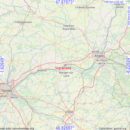
Ingrandes GPS coordinates[2]
47° 24' 18" North, 0° 55' 24.096" West
| Map corner | latitude | longitude |
|---|---|---|
| Upper-left | 47.87873°, | -1.62649° |
| Center: | 47.405°, | -0.92336° |
| Lower-right: | 46.92697°, | -0.22024° |
| Map W x H: | 105.8×105.8 km | = 65.7×65.7mi |
| max Lat: | 51.07786° ⇑50% North |
| Ingrandes: | 47.405° |
| min Lat: | ⇓50% South 41.3874° |
| min Long | Ingrandes | max Long |
| -5.08615° | -0.92336° | 9.52242° |
| W 12.5%⇐ | ⇒87.5% E |
Elevation
Elevation of Ingrandes is 23 m = 75 ft, and this is 170.7 m = 560 ft below average elevation for this country.
| Max E: |
2333 m = 7654 ft | 92.7% |
| Avg. | 193.7 m = 635 ft | |
| Ingrandes | 23 m = 75 ft | |
Min E: |
-1 m = -3 ft | 7.3% |
See also: France elevation on elevation.city.
Geographical zone
Ingrandes is located in North temperate zone (between Tropic of Cancer and the Arctic Circle). Distance of this North polar circle is 2130.2 km =1323.6 mi to North.| Distance of | km | miles | from Ingrandes |
|---|---|---|---|
| North Pole | 4736.1 | 2942.9 | to North |
| Arctic Circle | 2130.2 | 1323.6 | to North |
| Tropic Cancer | 2665 | 1656 | to South |
| Equator | 5270.9 | 3275.2 | to South |


Nearby cities:
15 places around Ingrandes: (largest is in red/bold)
• Belligné
10.5 km =6.5 mi,  311°
311°
• Champtocé-sur-Loire
4.5 km =2.8 mi,  79°
79°
• La Chapelle-Saint-Sauveur
6.1 km =3.8 mi, 311°
• La Pommeraye
7.3 km =4.5 mi,  138°
138°
• La Rouxière
11.6 km =7.2 mi,  291°
291°
• Le Fresne-sur-Loire
0.6 km =0.4 mi,  219°
219°
• Le Mesnil-en-Vallée
4.5 km =2.8 mi,  191°
191°
• Montjean-sur-Loire
5.2 km =3.2 mi,  110°
110°
• Saint-Augustin-des-Bois
11.4 km =7.1 mi,  57°
57°
• Saint-Florent-le-Vieil
8.5 km =5.3 mi,  234°
234°
• Saint-Georges-sur-Loire
12.2 km =7.6 mi,  88°
88°
• Saint-Germain-des-Prés
6.8 km =4.2 mi, 85°
• Saint-Laurent-du-Mottay
6.3 km =3.9 mi,  198°
198°
• Varades
8.2 km =5.1 mi,  253°
253°
• Villemoisan
7 km =4.3 mi,  19°
19°
Sources, notices
• [Note1] Compared only with cities in France existing in our database
• [Src1] Map data: © OpenStreetMap contributors (CC-BY-SA)
• [Src2] Other city data from geonames.org with taken over terms of usage.
• [Src3] Geographical zone / Annual Mean Temperature by Robert A. Rohde @ Wikipedia
