Le Mesnil-en-Vallée geodata
Le Mesnil-en-Vallée (Pays de la Loire) is a populated place; located in France in Europe/Paris (GMT+2) time zone. With population of 1,364 people, there are 6749 cities with bigger population in this country. Compared to other cities in France, 50.5% of cities are located further ↑North; 87.6% of cities are located further →East and 84.9% of cities have higher elevation than Le Mesnil-en-Vallée. Note1
Administrative division(s):
- Level 1: Pays de la Loire
- Level 2: Département de Maine-et-Loire
- Level 3: Arrondissement de Cholet
- Level 4: Mauges-sur-Loire


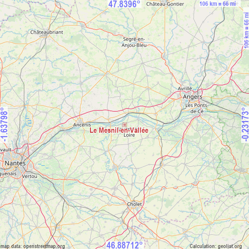
Le Mesnil-en-Vallée GPS coordinates[2]
47° 21' 55.836" North, 0° 56' 5.46" West
| Map corner | latitude | longitude |
|---|---|---|
| Upper-left | 47.8396°, | -1.63798° |
| Center: | 47.36551°, | -0.93485° |
| Lower-right: | 46.88712°, | -0.23173° |
| Map W x H: | 105.9×105.9 km | = 65.8×65.8mi |
| max Lat: | 51.07786° ⇑50.5% North |
| Le Mesnil-en-Vallée: | 47.36551° |
| min Lat: | ⇓49.5% South 41.3874° |
| min Long | Le Mesnil-en-Va | max Long |
| -5.08615° | -0.93485° | 9.52242° |
| W 12.4%⇐ | ⇒87.6% E |
Elevation
Elevation of Le Mesnil-en-Vallée is 42 m = 138 ft, and this is 151.7 m = 498 ft below average elevation for this country.
| Max E: |
2333 m = 7654 ft | 84.9% |
| Avg. | 193.7 m = 635 ft | |
| Le Mesnil-en-Vallée | 42 m = 138 ft | |
Min E: |
-1 m = -3 ft | 15.1% |
See also: France elevation on elevation.city.
Geographical zone
Le Mesnil-en-Vallée is located in North temperate zone (between Tropic of Cancer and the Arctic Circle). Distance of this North polar circle is 2134.6 km =1326.4 mi to North.| Distance of | km | miles | from Le Mesnil-en-Vallée |
|---|---|---|---|
| North Pole | 4740.5 | 2945.6 | to North |
| Arctic Circle | 2134.6 | 1326.4 | to North |
| Tropic Cancer | 2660.6 | 1653.2 | to South |
| Equator | 5266.6 | 3272.5 | to South |


Nearby cities:
15 places around Le Mesnil-en-Vallée: (largest is in red/bold)
• Botz-en-Mauges
8.2 km =5.1 mi,  217°
217°
• Bourgneuf-en-Mauges
9.5 km =5.9 mi,  128°
128°
• Champtocé-sur-Loire
7.4 km =4.6 mi,  45°
45°
• Chaudron-en-Mauges
9.4 km =5.8 mi,  203°
203°
• Ingrandes
4.5 km =2.8 mi,  11°
11°
• La Chapelle-Saint-Florent
9.8 km =6.1 mi,  249°
249°
• La Chapelle-Saint-Sauveur
9.2 km =5.7 mi,  335°
335°
• La Pommeraye
5.8 km =3.6 mi,  100°
100°
• Le Fresne-sur-Loire
4 km =2.5 mi, 7°
• Montjean-sur-Loire
6.3 km =3.9 mi,  66°
66°
• Saint-Florent-le-Vieil
6.1 km =3.8 mi,  264°
264°
• Saint-Germain-des-Prés
9.1 km =5.7 mi,  57°
57°
• Saint-Laurent-du-Mottay
1.9 km =1.2 mi,  214°
214°
• Saint-Quentin-en-Mauges
8.4 km =5.2 mi,  168°
168°
• Varades
7.4 km =4.6 mi,  286°
286°
Sources, notices
• [Note1] Compared only with cities in France existing in our database
• [Src1] Map data: © OpenStreetMap contributors (CC-BY-SA)
• [Src2] Other city data from geonames.org with taken over terms of usage.
• [Src3] Geographical zone / Annual Mean Temperature by Robert A. Rohde @ Wikipedia
