Montjean-sur-Loire geodata
Montjean-sur-Loire (Pays de la Loire) is a populated place; located in France in Europe/Paris (GMT+2) time zone. With population of 2,796 people, there are 3488 cities with bigger population in this country. Compared to other cities in France, 50.3% of cities are located further ↑North; 87% of cities are located further →East and 85.9% of cities have higher elevation than Montjean-sur-Loire. Note1
Administrative division(s):
- Level 1: Pays de la Loire
- Level 2: Département de Maine-et-Loire
- Level 3: Arrondissement de Cholet
- Level 4: Mauges-sur-Loire


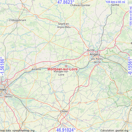
Montjean-sur-Loire GPS coordinates[2]
47° 23' 18.312" North, 0° 51' 31.428" West
| Map corner | latitude | longitude |
|---|---|---|
| Upper-left | 47.8623°, | -1.56186° |
| Center: | 47.38842°, | -0.85873° |
| Lower-right: | 46.91024°, | -0.15561° |
| Map W x H: | 105.9×105.9 km | = 65.8×65.8mi |
| max Lat: | 51.07786° ⇑50.3% North |
| Montjean-sur-Loire: | 47.38842° |
| min Lat: | ⇓49.7% South 41.3874° |
| min Long | Montjean-sur-Lo | max Long |
| -5.08615° | -0.85873° | 9.52242° |
| W 13%⇐ | ⇒87% E |
Elevation
Elevation of Montjean-sur-Loire is 40 m = 131 ft, and this is 153.7 m = 504 ft below average elevation for this country.
| Max E: |
2333 m = 7654 ft | 85.9% |
| Avg. | 193.7 m = 635 ft | |
| Montjean-sur-Loire | 40 m = 131 ft | |
Min E: |
-1 m = -3 ft | 14.1% |
See also: France elevation on elevation.city.
Geographical zone
Montjean-sur-Loire is located in North temperate zone (between Tropic of Cancer and the Arctic Circle). Distance of this North polar circle is 2132.1 km =1324.8 mi to North.| Distance of | km | miles | from Montjean-sur-Loire |
|---|---|---|---|
| North Pole | 4738 | 2944.1 | to North |
| Arctic Circle | 2132.1 | 1324.8 | to North |
| Tropic Cancer | 2663.2 | 1654.8 | to South |
| Equator | 5269.1 | 3274.1 | to South |


Nearby cities:
15 places around Montjean-sur-Loire: (largest is in red/bold)
• Bourgneuf-en-Mauges
8.6 km =5.3 mi,  168°
168°
• Chalonnes-sur-Loire
8.3 km =5.2 mi,  119°
119°
• Champtocé-sur-Loire
2.7 km =1.7 mi,  350°
350°
• Ingrandes
5.2 km =3.2 mi,  290°
290°
• La Chapelle-Saint-Sauveur
11.1 km =6.9 mi,  301°
301°
• La Pommeraye
3.6 km =2.2 mi,  180°
180°
• Le Fresne-sur-Loire
5.4 km =3.4 mi,  284°
284°
• Le Mesnil-en-Vallée
6.3 km =3.9 mi,  246°
246°
• Saint-Augustin-des-Bois
9.3 km =5.8 mi,  31°
31°
• Saint-Georges-sur-Loire
7.6 km =4.7 mi,  73°
73°
• Saint-Germain-des-Prés
3.1 km =1.9 mi,  38°
38°
• Saint-Laurent-de-la-Plaine
8.9 km =5.5 mi,  152°
152°
• Saint-Laurent-du-Mottay
8 km =5 mi,  238°
238°
• Sainte-Christine
11.3 km =7 mi, 175°
• Villemoisan
8.8 km =5.5 mi,  343°
343°
Sources, notices
• [Note1] Compared only with cities in France existing in our database
• [Src1] Map data: © OpenStreetMap contributors (CC-BY-SA)
• [Src2] Other city data from geonames.org with taken over terms of usage.
• [Src3] Geographical zone / Annual Mean Temperature by Robert A. Rohde @ Wikipedia
