Noailles geodata
Noailles (Hauts-de-France) is a populated place; located in France in Europe/Paris (GMT+2) time zone. With population of 2,790 people, there are 3498 cities with bigger population in this country. Compared to other cities in France, 86.6% of cities are located further ↓South; 54.4% of cities are located further →East and 63.6% of cities have higher elevation than Noailles. Note1
Administrative division(s):
- Level 1: Hauts-de-France
- Level 2: Département de l'Oise
- Level 3: Arrondissement de Beauvais
- Level 4: Noailles


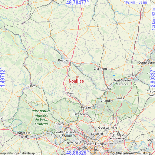
Noailles GPS coordinates[2]
49° 19' 43.176" North, 2° 12' 0.864" East
| Map corner | latitude | longitude |
|---|---|---|
| Upper-left | 49.78477°, | 1.49712° |
| Center: | 49.32866°, | 2.20024° |
| Lower-right: | 48.86829°, | 2.90337° |
| Map W x H: | 101.9×101.9 km | = 63.3×63.3mi |
| max Lat: | 51.07786° ⇑13.4% North |
| Noailles: | 49.32866° |
| min Lat: | ⇓86.6% South 41.3874° |
| min Long | Noailles | max Long |
| -5.08615° | 2.20024° | 9.52242° |
| W 45.6%⇐ | ⇒54.4% E |
Elevation
Elevation of Noailles is 93 m = 305 ft, and this is 100.7 m = 330 ft below average elevation for this country.
| Max E: |
2333 m = 7654 ft | 63.6% |
| Avg. | 193.7 m = 635 ft | |
| Noailles | 93 m = 305 ft | |
Min E: |
-1 m = -3 ft | 36.4% |
See also: France elevation on elevation.city.
Geographical zone
Noailles is located in North temperate zone (between Tropic of Cancer and the Arctic Circle). Distance of this North polar circle is 1916.3 km =1190.7 mi to North.| Distance of | km | miles | from Noailles |
|---|---|---|---|
| North Pole | 4522.2 | 2810 | to North |
| Arctic Circle | 1916.3 | 1190.7 | to North |
| Tropic Cancer | 2878.9 | 1788.9 | to South |
| Equator | 5484.8 | 3408.1 | to South |


Nearby cities:
15 places around Noailles: (largest is in red/bold)
• Bailleul-sur-Thérain
6.5 km =4 mi,  14°
14°
• Berthecourt
3 km =1.9 mi,  35°
35°
• Cauvigny
4.6 km =2.9 mi,  130°
130°
• Heilles
4.8 km =3 mi,  81°
81°
• Hermes
4.8 km =3 mi, 42°
• Hondainville
7.5 km =4.7 mi, 79°
• Laboissière-en-Thelle
4.8 km =3 mi,  215°
215°
• Lachapelle-Saint-Pierre
7.1 km =4.4 mi,  158°
158°
• Le Coudray-sur-Thelle
6.1 km =3.8 mi,  244°
244°
• Mortefontaine-en-Thelle
7.2 km =4.5 mi,  187°
187°
• Ponchon
2 km =1.2 mi,  352°
352°
• Saint-Félix
6.8 km =4.2 mi,  61°
61°
• Saint-Sulpice
6.1 km =3.8 mi,  293°
293°
• Sainte-Geneviève
4.4 km =2.7 mi,  181°
181°
• Villers-Saint-Sépulcre
4.3 km =2.7 mi, 14°
Sources, notices
• [Note1] Compared only with cities in France existing in our database
• [Src1] Map data: © OpenStreetMap contributors (CC-BY-SA)
• [Src2] Other city data from geonames.org with taken over terms of usage.
• [Src3] Geographical zone / Annual Mean Temperature by Robert A. Rohde @ Wikipedia
