Enchastrayes geodata
Enchastrayes (Provence-Alpes-Côte d'Azur) is a populated place; located in France in Europe/Paris (GMT+2) time zone. With population of 536 people, there are 14480 cities with bigger population in this country. Compared to other cities in France, 84.5% of cities are located further ↑North; 93% of cities are located further ←West and 99.9% of cities have lower elevation than Enchastrayes. Note1
Administrative division(s):
- Level 1: Provence-Alpes-Côte d'Azur
- Level 2: Alpes-de-Haute-Provence
- Level 3: Arrondissement de Barcelonnette
- Level 4: Enchastrayes


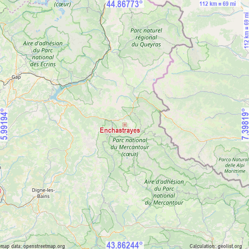
Enchastrayes GPS coordinates[2]
44° 22' 2.064" North, 6° 41' 42.216" East
| Map corner | latitude | longitude |
|---|---|---|
| Upper-left | 44.86773°, | 5.99194° |
| Center: | 44.36724°, | 6.69506° |
| Lower-right: | 43.86244°, | 7.39819° |
| Map W x H: | 111.8×111.8 km | = 69.5×69.5mi |
| max Lat: | 51.07786° ⇑84.5% North |
| Enchastrayes: | 44.36724° |
| min Lat: | ⇓15.5% South 41.3874° |
| min Long | Enchastrayes | max Long |
| -5.08615° | 6.69506° | 9.52242° |
| W 93%⇐ | ⇒7% E |
Elevation
Elevation of Enchastrayes is 1513 m = 4964 ft, and this is 1319.3 m = 4328 ft above average elevation for this country.
| Max E: |
2333 m = 7654 ft | 0.099999999999994% |
| Enchastrayes | 1513 m 4964 ft | |
| Avg. | 193.7 m = 635 ft | |
Min E: |
-1 m = -3 ft | 99.9% |
See also: France elevation on elevation.city.
Geographical zone
Enchastrayes is located in North temperate zone (between Tropic of Cancer and the Arctic Circle). Distance of this Northern Tropic circle is 2327.3 km =1446.1 mi to South.| Distance of | km | miles | from Enchastrayes |
|---|---|---|---|
| North Pole | 5073.9 | 3152.8 | to North |
| Arctic Circle | 2468 | 1533.5 | to North |
| Tropic Cancer | 2327.3 | 1446.1 | to South |
| Equator | 4933.2 | 3065.3 | to South |


Nearby cities:
15 places around Enchastrayes: (largest is in red/bold)
• Allos
15 km =9.3 mi,  200°
200°
• Barcelonnette
4.1 km =2.5 mi,  302°
302°
• Châteauroux-les-Alpes
30.8 km =19.1 mi,  333°
333°
• Embrun
27 km =16.8 mi,  324°
324°
• Guillaumes
33.3 km =20.7 mi,  157°
157°
• Guillestre
32.7 km =20.3 mi,  353°
353°
• Isola
34.9 km =21.7 mi,  125°
125°
• Jausiers
6.2 km =3.9 mi,  26°
26°
• Le Brusquet
38.3 km =23.8 mi,  233°
233°
• Péone
32.6 km =20.3 mi,  148°
148°
• Risoul
31.5 km =19.6 mi, 351°
• Saint-Étienne-de-Tinée
22.1 km =13.7 mi,  123°
123°
• Savines-le-Lac
29.1 km =18.1 mi,  307°
307°
• Seyne-les-Alpes
27 km =16.8 mi,  266°
266°
• Vars
25.6 km =15.9 mi,  359°
359°
Sources, notices
• [Note1] Compared only with cities in France existing in our database
• [Src1] Map data: © OpenStreetMap contributors (CC-BY-SA)
• [Src2] Other city data from geonames.org with taken over terms of usage.
• [Src3] Geographical zone / Annual Mean Temperature by Robert A. Rohde @ Wikipedia
