Allos geodata
Allos (Provence-Alpes-Côte d'Azur) is a populated place; located in France in Europe/Paris (GMT+2) time zone. With population of 677 people, there are 12108 cities with bigger population in this country. Compared to other cities in France, 85.2% of cities are located further ↑North; 92.5% of cities are located further ←West and 99.9% of cities have lower elevation than Allos. Note1
Administrative division(s):
- Level 1: Provence-Alpes-Côte d'Azur
- Level 2: Alpes-de-Haute-Provence
- Level 3: Arrondissement de Castellane
- Level 4: Allos


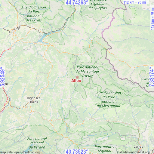
Allos GPS coordinates[2]
44° 14' 27.996" North, 6° 37' 42.996" East
| Map corner | latitude | longitude |
|---|---|---|
| Upper-left | 44.74268°, | 5.92549° |
| Center: | 44.24111°, | 6.62861° |
| Lower-right: | 43.73523°, | 7.33174° |
| Map W x H: | 112×112 km | = 69.6×69.6mi |
| max Lat: | 51.07786° ⇑85.2% North |
| Allos: | 44.24111° |
| min Lat: | ⇓14.8% South 41.3874° |
| min Long | Allos | max Long |
| -5.08615° | 6.62861° | 9.52242° |
| W 92.5%⇐ | ⇒7.5% E |
Elevation
Elevation of Allos is 1438 m = 4718 ft, and this is 1244.3 m = 4082 ft above average elevation for this country.
| Max E: |
2333 m = 7654 ft | 0.099999999999994% |
| Allos | 1438 m 4718 ft | |
| Avg. | 193.7 m = 635 ft | |
Min E: |
-1 m = -3 ft | 99.9% |
See also: France elevation on elevation.city.
Geographical zone
Allos is located in North temperate zone (between Tropic of Cancer and the Arctic Circle). Distance of this Northern Tropic circle is 2313.2 km =1437.4 mi to South.| Distance of | km | miles | from Allos |
|---|---|---|---|
| North Pole | 5087.9 | 3161.5 | to North |
| Arctic Circle | 2482 | 1542.2 | to North |
| Tropic Cancer | 2313.2 | 1437.4 | to South |
| Equator | 4919.2 | 3056.6 | to South |


Nearby cities:
15 places around Allos: (largest is in red/bold)
• Annot
30.8 km =19.1 mi,  174°
174°
• Barcelonnette
16.3 km =10.1 mi,  6°
6°
• Digne-les-Bains
35.7 km =22.2 mi,  242°
242°
• Embrun
37.4 km =23.2 mi,  343°
343°
• Enchastrayes
15 km =9.3 mi,  20°
20°
• Entrevaux
35.5 km =22.1 mi,  155°
155°
• Guillaumes
24.5 km =15.2 mi,  133°
133°
• Isola
34.4 km =21.4 mi,  100°
100°
• Jausiers
21.1 km =13.1 mi, 22°
• Le Brusquet
27 km =16.8 mi,  250°
250°
• Péone
26.1 km =16.2 mi,  122°
122°
• Saint-André-les-Alpes
31.9 km =19.8 mi,  197°
197°
• Saint-Étienne-de-Tinée
23.7 km =14.7 mi,  85°
85°
• Savines-le-Lac
36.4 km =22.6 mi,  330°
330°
• Seyne-les-Alpes
24.8 km =15.4 mi,  299°
299°
Sources, notices
• [Note1] Compared only with cities in France existing in our database
• [Src1] Map data: © OpenStreetMap contributors (CC-BY-SA)
• [Src2] Other city data from geonames.org with taken over terms of usage.
• [Src3] Geographical zone / Annual Mean Temperature by Robert A. Rohde @ Wikipedia
