Vermelles geodata
Vermelles (Hauts-de-France) is a populated place; located in France in Europe/Paris (GMT+2) time zone. With population of 4,568 people, there are 2164 cities with bigger population in this country. Compared to other cities in France, 97.2% of cities are located further ↓South; 54.2% of cities are located further ←West and 89.1% of cities have higher elevation than Vermelles. Note1
Administrative division(s):
- Level 1: Hauts-de-France
- Level 2: Pas-de-Calais
- Level 3: Arrondissement de Béthune
- Level 4: Vermelles


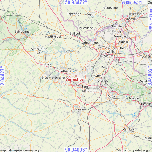
Vermelles GPS coordinates[2]
50° 29' 22.164" North, 2° 44' 50.604" East
| Map corner | latitude | longitude |
|---|---|---|
| Upper-left | 50.93472°, | 2.04427° |
| Center: | 50.48949°, | 2.74739° |
| Lower-right: | 50.04003°, | 3.45052° |
| Map W x H: | 99.5×99.5 km | = 61.8×61.8mi |
| max Lat: | 51.07786° ⇑2.8% North |
| Vermelles: | 50.48949° |
| min Lat: | ⇓97.2% South 41.3874° |
| min Long | Vermelles | max Long |
| -5.08615° | 2.74739° | 9.52242° |
| W 54.2%⇐ | ⇒45.8% E |
Elevation
Elevation of Vermelles is 32 m = 105 ft, and this is 161.7 m = 531 ft below average elevation for this country.
| Max E: |
2333 m = 7654 ft | 89.1% |
| Avg. | 193.7 m = 635 ft | |
| Vermelles | 32 m = 105 ft | |
Min E: |
-1 m = -3 ft | 10.9% |
See also: France elevation on elevation.city.
Geographical zone
Vermelles is located in North temperate zone (between Tropic of Cancer and the Arctic Circle). Distance of this North polar circle is 1787.3 km =1110.6 mi to North.| Distance of | km | miles | from Vermelles |
|---|---|---|---|
| North Pole | 4393.2 | 2729.8 | to North |
| Arctic Circle | 1787.3 | 1110.6 | to North |
| Tropic Cancer | 3008 | 1869.1 | to South |
| Equator | 5613.9 | 3488.3 | to South |


Nearby cities:
15 places around Vermelles: (largest is in red/bold)
• Annequin
2.6 km =1.6 mi,  312°
312°
• Auchy-les-Mines
3.7 km =2.3 mi,  43°
43°
• Beuvry
5.3 km =3.3 mi,  304°
304°
• Bully-les-Mines
5.3 km =3.3 mi,  195°
195°
• Cambrin
2.3 km =1.4 mi,  348°
348°
• Cuinchy
3.1 km =1.9 mi,  1°
1°
• Grenay
4.4 km =2.7 mi,  176°
176°
• Haisnes
3.9 km =2.4 mi,  58°
58°
• Hulluch
4.6 km =2.9 mi,  89°
89°
• Labourse
4.8 km =3 mi,  282°
282°
• Loos-en-Gohelle
4.7 km =2.9 mi,  137°
137°
• Mazingarbe
3 km =1.9 mi,  227°
227°
• Noyelles-lès-Vermelles
1.5 km =0.9 mi,  272°
272°
• Nœux-les-Mines
5.8 km =3.6 mi,  263°
263°
• Sailly-Labourse
3.8 km =2.4 mi,  290°
290°
Sources, notices
• [Note1] Compared only with cities in France existing in our database
• [Src1] Map data: © OpenStreetMap contributors (CC-BY-SA)
• [Src2] Other city data from geonames.org with taken over terms of usage.
• [Src3] Geographical zone / Annual Mean Temperature by Robert A. Rohde @ Wikipedia
