Gray geodata
Gray (Bourgogne-Franche-Comté) is a populated place; located in France in Europe/Paris (GMT+2) time zone. With population of 7,402 people, there are 1322 cities with bigger population in this country. Compared to other cities in France, 50.5% of cities are located further ↓South; 83.7% of cities are located further ←West and 70.9% of cities have lower elevation than Gray. Note1
Administrative division(s):
- Level 1: Bourgogne-Franche-Comté
- Level 2: Département de la Haute-Saône
- Level 3: Arrondissement de Vesoul
- Level 4: Gray


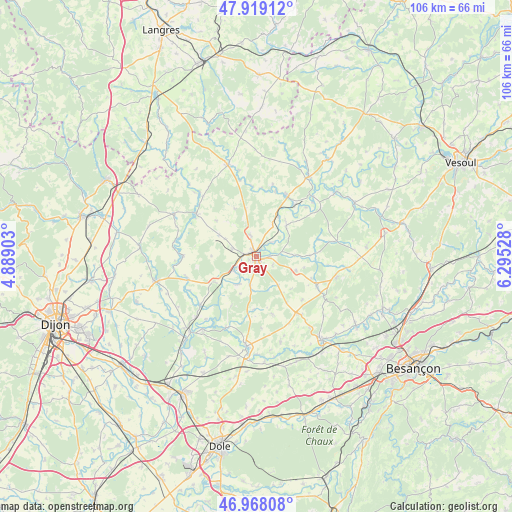
Gray GPS coordinates[2]
47° 26' 44.7" North, 5° 35' 31.74" East
| Map corner | latitude | longitude |
|---|---|---|
| Upper-left | 47.91912°, | 4.88903° |
| Center: | 47.44575°, | 5.59215° |
| Lower-right: | 46.96808°, | 6.29528° |
| Map W x H: | 105.7×105.7 km | = 65.7×65.7mi |
| max Lat: | 51.07786° ⇑49.5% North |
| Gray: | 47.44575° |
| min Lat: | ⇓50.5% South 41.3874° |
| min Long | Gray | max Long |
| -5.08615° | 5.59215° | 9.52242° |
| W 83.7%⇐ | ⇒16.3% E |
Elevation
Elevation of Gray is 223 m = 732 ft, and this is 29.3 m = 96 ft above average elevation for this country.
| Max E: |
2333 m = 7654 ft | 29.1% |
| Gray | 223 m 732 ft | |
| Avg. | 193.7 m = 635 ft | |
Min E: |
-1 m = -3 ft | 70.9% |
See also: France elevation on elevation.city.
Geographical zone
Gray is located in North temperate zone (between Tropic of Cancer and the Arctic Circle). Distance of this North polar circle is 2125.7 km =1320.8 mi to North.| Distance of | km | miles | from Gray |
|---|---|---|---|
| North Pole | 4731.6 | 2940.1 | to North |
| Arctic Circle | 2125.7 | 1320.8 | to North |
| Tropic Cancer | 2669.6 | 1658.8 | to South |
| Equator | 5275.5 | 3278 | to South |


Nearby cities:
15 places around Gray: (largest is in red/bold)
• Arc-lès-Gray
1.3 km =0.8 mi,  338°
338°
• Beaujeu-Saint-Vallier-Pierrejux-et-Quitteur
9.1 km =5.7 mi,  48°
48°
• Bucey-lès-Gy
19 km =11.8 mi,  97°
97°
• Champlitte
19.8 km =12.3 mi, 343°
• Champlitte-la-Ville
19.2 km =11.9 mi,  346°
346°
• Chargey-lès-Gray
4.5 km =2.8 mi, 346°
• Dampierre-sur-Salon
14 km =8.7 mi,  27°
27°
• Fontaine-Française
18.3 km =11.4 mi,  295°
295°
• Gray-la-Ville
1.6 km =1 mi,  244°
244°
• Gy
17.1 km =10.6 mi, 104°
• Mantoche
5.5 km =3.4 mi, 237°
• Nantilly
5.1 km =3.2 mi,  286°
286°
• Pesmes
18.5 km =11.5 mi,  185°
185°
• Rigny
4.1 km =2.5 mi, 45°
• Valay
12.4 km =7.7 mi,  163°
163°
Sources, notices
• [Note1] Compared only with cities in France existing in our database
• [Src1] Map data: © OpenStreetMap contributors (CC-BY-SA)
• [Src2] Other city data from geonames.org with taken over terms of usage.
• [Src3] Geographical zone / Annual Mean Temperature by Robert A. Rohde @ Wikipedia
