Saint-Aubin-Routot geodata
Saint-Aubin-Routot (Normandy) is a populated place; located in France in Europe/Paris (GMT+2) time zone. With population of 1,150 people, there are 7821 cities with bigger population in this country. Compared to other cities in France, 89.6% of cities are located further ↓South; 75.1% of cities are located further →East and 60.4% of cities have higher elevation than Saint-Aubin-Routot. Note1
Administrative division(s):
- Level 1: Normandy
- Level 2: Seine-Maritime
- Level 3: Arrondissement du Havre
- Level 4: Saint-Aubin-Routot


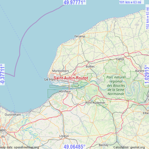
Saint-Aubin-Routot GPS coordinates[2]
49° 31' 24.276" North, 0° 19' 33.672" East
| Map corner | latitude | longitude |
|---|---|---|
| Upper-left | 49.97771°, | -0.37711° |
| Center: | 49.52341°, | 0.32602° |
| Lower-right: | 49.06485°, | 1.02915° |
| Map W x H: | 101.5×101.5 km | = 63.1×63.1mi |
| max Lat: | 51.07786° ⇑10.4% North |
| Saint-Aubin-Routot: | 49.52341° |
| min Lat: | ⇓89.6% South 41.3874° |
| min Long | Saint-Aubin-Rou | max Long |
| -5.08615° | 0.32602° | 9.52242° |
| W 24.9%⇐ | ⇒75.1% E |
Elevation
Elevation of Saint-Aubin-Routot is 101 m = 331 ft, and this is 92.7 m = 304 ft below average elevation for this country.
| Max E: |
2333 m = 7654 ft | 60.4% |
| Avg. | 193.7 m = 635 ft | |
| Saint-Aubin-Routot | 101 m = 331 ft | |
Min E: |
-1 m = -3 ft | 39.6% |
See also: France elevation on elevation.city.
Geographical zone
Saint-Aubin-Routot is located in North temperate zone (between Tropic of Cancer and the Arctic Circle). Distance of this North polar circle is 1894.7 km =1177.3 mi to North.| Distance of | km | miles | from Saint-Aubin-Routot |
|---|---|---|---|
| North Pole | 4500.6 | 2796.5 | to North |
| Arctic Circle | 1894.7 | 1177.3 | to North |
| Tropic Cancer | 2900.6 | 1802.3 | to South |
| Equator | 5506.5 | 3421.6 | to South |


Nearby cities:
15 places around Saint-Aubin-Routot: (largest is in red/bold)
• Gainneville
4.7 km =2.9 mi,  263°
263°
• Gommerville
4.7 km =2.9 mi,  40°
40°
• Graimbouville
5.8 km =3.6 mi,  4°
4°
• La Cerlangue
6.6 km =4.1 mi,  107°
107°
• La Remuée
5.6 km =3.5 mi,  85°
85°
• Rogerville
4.9 km =3 mi,  242°
242°
• Sainneville
4.5 km =2.8 mi,  323°
323°
• Saint-Gilles-de-la-Neuville
6.7 km =4.2 mi,  31°
31°
• Saint-Laurent-de-Brévedent
5.2 km =3.2 mi,  272°
272°
• Saint-Martin-du-Manoir
6.5 km =4 mi,  278°
278°
• Saint-Romain-de-Colbosc
2.4 km =1.5 mi,  69°
69°
• Saint-Vincent-Cramesnil
3.4 km =2.1 mi,  132°
132°
• Sandouville
2.9 km =1.8 mi,  192°
192°
• Épretot
1.9 km =1.2 mi,  338°
338°
• Étainhus
4.9 km =3 mi,  348°
348°
Sources, notices
• [Note1] Compared only with cities in France existing in our database
• [Src1] Map data: © OpenStreetMap contributors (CC-BY-SA)
• [Src2] Other city data from geonames.org with taken over terms of usage.
• [Src3] Geographical zone / Annual Mean Temperature by Robert A. Rohde @ Wikipedia
