Carency geodata
Carency (Hauts-de-France) is a populated place; located in France in Europe/Paris (GMT+2) time zone. With population of 707 people, there are 11704 cities with bigger population in this country. Compared to other cities in France, 96.3% of cities are located further ↓South; 53.5% of cities are located further ←West and 58.7% of cities have higher elevation than Carency. Note1
Administrative division(s):
- Level 1: Hauts-de-France
- Level 2: Pas-de-Calais
- Level 3: Arrondissement de Lens
- Level 4: Carency


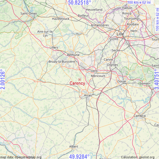
Carency GPS coordinates[2]
50° 22' 44.076" North, 2° 42' 15.804" East
| Map corner | latitude | longitude |
|---|---|---|
| Upper-left | 50.82518°, | 2.00126° |
| Center: | 50.37891°, | 2.70439° |
| Lower-right: | 49.9284°, | 3.40751° |
| Map W x H: | 99.7×99.7 km | = 62×62mi |
| max Lat: | 51.07786° ⇑3.7% North |
| Carency: | 50.37891° |
| min Lat: | ⇓96.3% South 41.3874° |
| min Long | Carency | max Long |
| -5.08615° | 2.70439° | 9.52242° |
| W 53.5%⇐ | ⇒46.5% E |
Elevation
Elevation of Carency is 106 m = 348 ft, and this is 87.7 m = 288 ft below average elevation for this country.
| Max E: |
2333 m = 7654 ft | 58.7% |
| Avg. | 193.7 m = 635 ft | |
| Carency | 106 m = 348 ft | |
Min E: |
-1 m = -3 ft | 41.3% |
See also: France elevation on elevation.city.
Geographical zone
Carency is located in North temperate zone (between Tropic of Cancer and the Arctic Circle). Distance of this North polar circle is 1799.6 km =1118.2 mi to North.| Distance of | km | miles | from Carency |
|---|---|---|---|
| North Pole | 4405.5 | 2737.4 | to North |
| Arctic Circle | 1799.6 | 1118.2 | to North |
| Tropic Cancer | 2995.7 | 1861.4 | to South |
| Equator | 5601.6 | 3480.7 | to South |


Nearby cities:
15 places around Carency: (largest is in red/bold)
• Ablain-Saint-Nazaire
1.6 km =1 mi,  11°
11°
• Acq
4.8 km =3 mi,  223°
223°
• Aix-Noulette
5.2 km =3.2 mi,  0°
0°
• Angres
5 km =3.1 mi,  53°
53°
• Bouvigny-Boyeffles
5.3 km =3.3 mi,  334°
334°
• Bully-les-Mines
7.4 km =4.6 mi, 12°
• Givenchy-en-Gohelle
5.1 km =3.2 mi,  74°
74°
• Liévin
7.1 km =4.4 mi, 49°
• Marœuil
6 km =3.7 mi,  179°
179°
• Mont-Saint-Éloi
3.2 km =2 mi,  195°
195°
• Neuville-Saint-Vaast
4.8 km =3 mi,  119°
119°
• Servins
6.1 km =3.8 mi,  304°
304°
• Souchez
3 km =1.9 mi,  58°
58°
• Thélus
7.4 km =4.6 mi,  111°
111°
• Vimy
7.5 km =4.7 mi,  95°
95°
Sources, notices
• [Note1] Compared only with cities in France existing in our database
• [Src1] Map data: © OpenStreetMap contributors (CC-BY-SA)
• [Src2] Other city data from geonames.org with taken over terms of usage.
• [Src3] Geographical zone / Annual Mean Temperature by Robert A. Rohde @ Wikipedia
