Ger geodata
Ger (Normandy) is a populated place; located in France in Europe/Paris (GMT+2) time zone. With population of 972 people, there are 9049 cities with bigger population in this country. Compared to other cities in France, 72.8% of cities are located further ↓South; 86.3% of cities are located further →East and 81.3% of cities have lower elevation than Ger. Note1


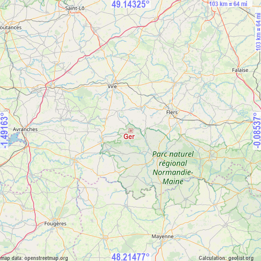
Ger GPS coordinates[2]
48° 40' 52.14" North, 0° 47' 18.6" West
| Map corner | latitude | longitude |
|---|---|---|
| Upper-left | 49.14325°, | -1.49163° |
| Center: | 48.68115°, | -0.7885° |
| Lower-right: | 48.21477°, | -0.08537° |
| Map W x H: | 103.2×103.2 km | = 64.1×64.1mi |
| max Lat: | 51.07786° ⇑27.2% North |
| Ger: | 48.68115° |
| min Lat: | ⇓72.8% South 41.3874° |
| min Long | Ger | max Long |
| -5.08615° | -0.7885° | 9.52242° |
| W 13.7%⇐ | ⇒86.3% E |
Elevation
Elevation of Ger is 303 m = 994 ft, and this is 109.3 m = 359 ft above average elevation for this country.
| Max E: |
2333 m = 7654 ft | 18.7% |
| Ger | 303 m 994 ft | |
| Avg. | 193.7 m = 635 ft | |
Min E: |
-1 m = -3 ft | 81.3% |
See also: France elevation on elevation.city.
Geographical zone
Ger is located in North temperate zone (between Tropic of Cancer and the Arctic Circle). Distance of this North polar circle is 1988.3 km =1235.5 mi to North.| Distance of | km | miles | from Ger |
|---|---|---|---|
| North Pole | 4594.2 | 2854.7 | to North |
| Arctic Circle | 1988.3 | 1235.5 | to North |
| Tropic Cancer | 2806.9 | 1744.1 | to South |
| Equator | 5412.8 | 3363.4 | to South |


Nearby cities:
15 places around Ger: (largest is in red/bold)
• Barenton
9.6 km =6 mi,  199°
199°
• Chanu
9.8 km =6.1 mi,  57°
57°
• La Haute-Chapelle
12.1 km =7.5 mi,  134°
134°
• Landisacq
13.2 km =8.2 mi,  50°
50°
• Le Neufbourg
12.1 km =7.5 mi,  256°
256°
• Mortain
11.8 km =7.3 mi,  251°
251°
• Saint-Bômer-les-Forges
12.1 km =7.5 mi,  109°
109°
• Saint-Clair-de-Halouze
11.8 km =7.3 mi,  91°
91°
• Saint-Clément-Rancoudray
7.1 km =4.4 mi, 256°
• Saint-Cornier-des-Landes
6.5 km =4 mi, 51°
• Saint-Georges-de-Rouelley
8.8 km =5.5 mi,  170°
170°
• Sourdeval
10.9 km =6.8 mi,  295°
295°
• Tinchebray
10.1 km =6.3 mi,  23°
23°
• Truttemer-le-Grand
11.3 km =7 mi,  348°
348°
• Vengeons
12.4 km =7.7 mi,  310°
310°
Sources, notices
• [Note1] Compared only with cities in France existing in our database
• [Src1] Map data: © OpenStreetMap contributors (CC-BY-SA)
• [Src2] Other city data from geonames.org with taken over terms of usage.
• [Src3] Geographical zone / Annual Mean Temperature by Robert A. Rohde @ Wikipedia
