Gâtelles geodata
Gâtelles (Centre) is a populated place; located in France in Europe/Paris (GMT+2) time zone. With population of 952 people, there are 9192 cities with bigger population in this country. Compared to other cities in France, 69.4% of cities are located further ↓South; 65.7% of cities are located further →East and 73% of cities have lower elevation than Gâtelles. Note1
Administrative division(s):
- Level 1: Centre
- Level 2: Département d'Eure-et-Loir
- Level 3: Arrondissement de Dreux
- Level 4: Thimert-Gâtelles


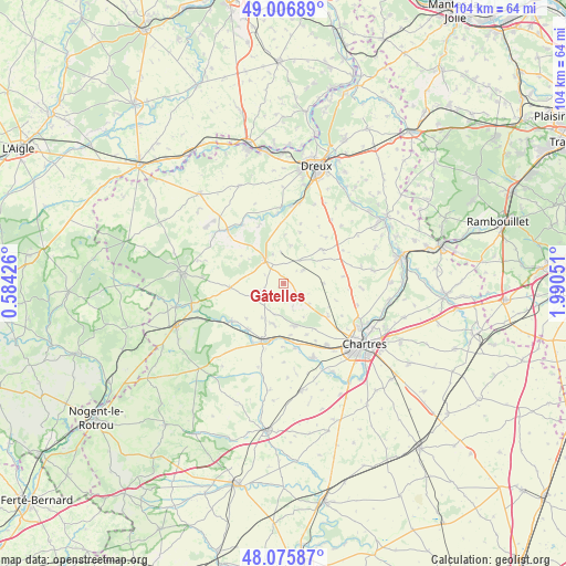
Gâtelles GPS coordinates[2]
48° 32' 36.672" North, 1° 17' 14.568" East
| Map corner | latitude | longitude |
|---|---|---|
| Upper-left | 49.00689°, | 0.58426° |
| Center: | 48.54352°, | 1.28738° |
| Lower-right: | 48.07587°, | 1.99051° |
| Map W x H: | 103.5×103.5 km | = 64.3×64.3mi |
| max Lat: | 51.07786° ⇑30.6% North |
| Gâtelles: | 48.54352° |
| min Lat: | ⇓69.4% South 41.3874° |
| min Long | Gâtelles | max Long |
| -5.08615° | 1.28738° | 9.52242° |
| W 34.3%⇐ | ⇒65.7% E |
Elevation
Elevation of Gâtelles is 236 m = 774 ft, and this is 42.3 m = 139 ft above average elevation for this country.
| Max E: |
2333 m = 7654 ft | 27% |
| Gâtelles | 236 m 774 ft | |
| Avg. | 193.7 m = 635 ft | |
Min E: |
-1 m = -3 ft | 73% |
See also: France elevation on elevation.city.
Geographical zone
Gâtelles is located in North temperate zone (between Tropic of Cancer and the Arctic Circle). Distance of this North polar circle is 2003.6 km =1245 mi to North.| Distance of | km | miles | from Gâtelles |
|---|---|---|---|
| North Pole | 4609.5 | 2864.2 | to North |
| Arctic Circle | 2003.6 | 1245 | to North |
| Tropic Cancer | 2791.6 | 1734.6 | to South |
| Equator | 5397.5 | 3353.8 | to South |


Nearby cities:
15 places around Gâtelles: (largest is in red/bold)
• Amilly
13.6 km =8.5 mi,  144°
144°
• Bailleau-l’Évêque
10 km =6.2 mi,  126°
126°
• Chuisnes
12.3 km =7.6 mi,  208°
208°
• Châteauneuf-en-Thymerais
5.4 km =3.4 mi,  320°
320°
• Clévilliers
7.3 km =4.5 mi,  89°
89°
• Courville-sur-Eure
11.1 km =6.9 mi,  198°
198°
• Digny
9.9 km =6.2 mi,  265°
265°
• Fontaine-la-Guyon
8.1 km =5 mi,  165°
165°
• Landelles
10.7 km =6.6 mi,  218°
218°
• Pontgouin
11.6 km =7.2 mi,  233°
233°
• Saint-Arnoult-des-Bois
6 km =3.7 mi, 197°
• Saint-Aubin-des-Bois
10.1 km =6.3 mi,  149°
149°
• Saint-Luperce
12.2 km =7.6 mi, 170°
• Saint-Sauveur-Marville
6.3 km =3.9 mi,  357°
357°
• Saulnières
12.9 km =8 mi,  354°
354°
Sources, notices
• [Note1] Compared only with cities in France existing in our database
• [Src1] Map data: © OpenStreetMap contributors (CC-BY-SA)
• [Src2] Other city data from geonames.org with taken over terms of usage.
• [Src3] Geographical zone / Annual Mean Temperature by Robert A. Rohde @ Wikipedia
