Amilly geodata
Amilly (Centre) is a populated place; located in France in Europe/Paris (GMT+2) time zone. With population of 1,942 people, there are 4927 cities with bigger population in this country. Compared to other cities in France, 67.1% of cities are located further ↓South; 64.4% of cities are located further →East and 58.4% of cities have lower elevation than Amilly. Note1
Administrative division(s):
- Level 1: Centre
- Level 2: Département d'Eure-et-Loir
- Level 3: Arrondissement de Chartres
- Level 4: Amilly


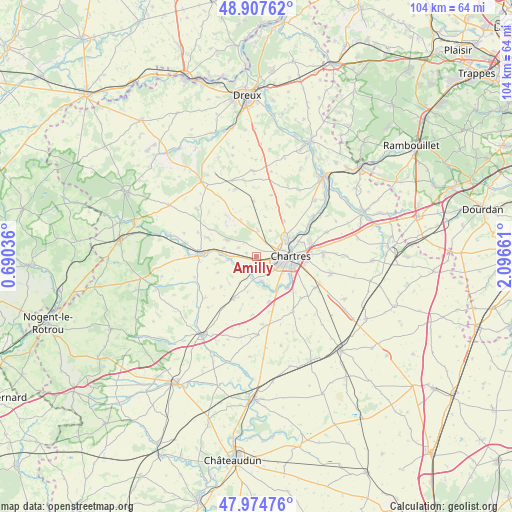
Amilly GPS coordinates[2]
48° 26' 35.988" North, 1° 23' 36.564" East
| Map corner | latitude | longitude |
|---|---|---|
| Upper-left | 48.90762°, | 0.69036° |
| Center: | 48.44333°, | 1.39349° |
| Lower-right: | 47.97476°, | 2.09661° |
| Map W x H: | 103.7×103.7 km | = 64.4×64.4mi |
| max Lat: | 51.07786° ⇑32.9% North |
| Amilly: | 48.44333° |
| min Lat: | ⇓67.1% South 41.3874° |
| min Long | Amilly | max Long |
| -5.08615° | 1.39349° | 9.52242° |
| W 35.6%⇐ | ⇒64.4% E |
Elevation
Elevation of Amilly is 163 m = 535 ft, and this is 30.7 m = 101 ft below average elevation for this country.
| Max E: |
2333 m = 7654 ft | 41.6% |
| Avg. | 193.7 m = 635 ft | |
| Amilly | 163 m = 535 ft | |
Min E: |
-1 m = -3 ft | 58.4% |
See also: France elevation on elevation.city.
Geographical zone
Amilly is located in North temperate zone (between Tropic of Cancer and the Arctic Circle). Distance of this North polar circle is 2014.8 km =1251.9 mi to North.| Distance of | km | miles | from Amilly |
|---|---|---|---|
| North Pole | 4620.7 | 2871.2 | to North |
| Arctic Circle | 2014.8 | 1251.9 | to North |
| Tropic Cancer | 2780.5 | 1727.7 | to South |
| Equator | 5386.4 | 3347 | to South |


Nearby cities:
15 places around Amilly: (largest is in red/bold)
• Bailleau-l’Évêque
5.2 km =3.2 mi,  2°
2°
• Barjouville
7.2 km =4.5 mi,  121°
121°
• Champhol
8.5 km =5.3 mi,  71°
71°
• Chartres
7.1 km =4.4 mi,  86°
86°
• Fontaine-la-Guyon
6.7 km =4.2 mi,  299°
299°
• Fontenay-sur-Eure
5.5 km =3.4 mi,  165°
165°
• Le Coudray
8.3 km =5.2 mi,  107°
107°
• Lucé
5.2 km =3.2 mi,  97°
97°
• Luisant
6.1 km =3.8 mi, 104°
• Lèves
7.2 km =4.5 mi, 65°
• Mainvilliers
4.7 km =2.9 mi,  80°
80°
• Saint-Aubin-des-Bois
3.6 km =2.2 mi,  313°
313°
• Saint-Georges-sur-Eure
4 km =2.5 mi,  226°
226°
• Saint-Luperce
5.8 km =3.6 mi,  261°
261°
• Thivars
8.4 km =5.2 mi,  149°
149°
Sources, notices
• [Note1] Compared only with cities in France existing in our database
• [Src1] Map data: © OpenStreetMap contributors (CC-BY-SA)
• [Src2] Other city data from geonames.org with taken over terms of usage.
• [Src3] Geographical zone / Annual Mean Temperature by Robert A. Rohde @ Wikipedia
