Fontaine-la-Guyon geodata
Fontaine-la-Guyon (Centre) is a populated place; located in France in Europe/Paris (GMT+2) time zone. With population of 1,100 people, there are 8130 cities with bigger population in this country. Compared to other cities in France, 67.7% of cities are located further ↓South; 65.4% of cities are located further →East and 60.9% of cities have lower elevation than Fontaine-la-Guyon. Note1
Administrative division(s):
- Level 1: Centre
- Level 2: Département d'Eure-et-Loir
- Level 3: Arrondissement de Chartres
- Level 4: Fontaine-la-Guyon


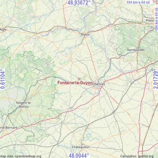
Fontaine-la-Guyon GPS coordinates[2]
48° 28' 21.72" North, 1° 18' 51.012" East
| Map corner | latitude | longitude |
|---|---|---|
| Upper-left | 48.93672°, | 0.61104° |
| Center: | 48.4727°, | 1.31417° |
| Lower-right: | 48.0044°, | 2.01729° |
| Map W x H: | 103.7×103.7 km | = 64.4×64.4mi |
| max Lat: | 51.07786° ⇑32.3% North |
| Fontaine-la-Guyon: | 48.4727° |
| min Lat: | ⇓67.7% South 41.3874° |
| min Long | Fontaine-la-Guy | max Long |
| -5.08615° | 1.31417° | 9.52242° |
| W 34.6%⇐ | ⇒65.4% E |
Elevation
Elevation of Fontaine-la-Guyon is 174 m = 571 ft, and this is 19.7 m = 65 ft below average elevation for this country.
| Max E: |
2333 m = 7654 ft | 39.1% |
| Avg. | 193.7 m = 635 ft | |
| Fontaine-la-Guyon | 174 m = 571 ft | |
Min E: |
-1 m = -3 ft | 60.9% |
See also: France elevation on elevation.city.
Geographical zone
Fontaine-la-Guyon is located in North temperate zone (between Tropic of Cancer and the Arctic Circle). Distance of this North polar circle is 2011.5 km =1249.9 mi to North.| Distance of | km | miles | from Fontaine-la-Guyon |
|---|---|---|---|
| North Pole | 4617.4 | 2869.1 | to North |
| Arctic Circle | 2011.5 | 1249.9 | to North |
| Tropic Cancer | 2783.7 | 1729.7 | to South |
| Equator | 5389.7 | 3349 | to South |


Nearby cities:
15 places around Fontaine-la-Guyon: (largest is in red/bold)
• Amilly
6.7 km =4.2 mi,  119°
119°
• Bailleau-l’Évêque
6.4 km =4 mi,  72°
72°
• Chuisnes
8.4 km =5.2 mi,  249°
249°
• Clévilliers
9.5 km =5.9 mi,  33°
33°
• Courville-sur-Eure
6 km =3.7 mi,  244°
244°
• Fontenay-sur-Eure
11.2 km =7 mi,  139°
139°
• Gâtelles
8.1 km =5 mi,  345°
345°
• Landelles
8.6 km =5.3 mi,  266°
266°
• Mainvilliers
10.8 km =6.7 mi,  103°
103°
• Ollé
9.4 km =5.8 mi,  187°
187°
• Pontgouin
11.4 km =7.1 mi,  275°
275°
• Saint-Arnoult-des-Bois
4.3 km =2.7 mi,  299°
299°
• Saint-Aubin-des-Bois
3.3 km =2.1 mi, 103°
• Saint-Georges-sur-Eure
6.7 km =4.2 mi,  153°
153°
• Saint-Luperce
4.1 km =2.5 mi,  178°
178°
Sources, notices
• [Note1] Compared only with cities in France existing in our database
• [Src1] Map data: © OpenStreetMap contributors (CC-BY-SA)
• [Src2] Other city data from geonames.org with taken over terms of usage.
• [Src3] Geographical zone / Annual Mean Temperature by Robert A. Rohde @ Wikipedia
