Fontoy geodata
Fontoy (Grand Est) is a populated place; located in France in Europe/Paris (GMT+2) time zone. With population of 3,250 people, there are 3003 cities with bigger population in this country. Compared to other cities in France, 87.1% of cities are located further ↓South; 87% of cities are located further ←West and 79.4% of cities have lower elevation than Fontoy. Note1
Administrative division(s):
- Level 1: Grand Est
- Level 2: Moselle
- Level 3: Arrondissement de Thionville
- Level 4: Fontoy


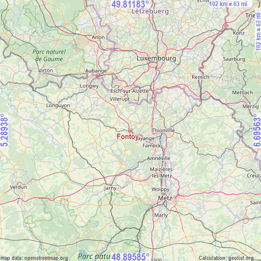
Fontoy GPS coordinates[2]
49° 21' 21.492" North, 5° 59' 33" East
| Map corner | latitude | longitude |
|---|---|---|
| Upper-left | 49.81183°, | 5.28938° |
| Center: | 49.35597°, | 5.9925° |
| Lower-right: | 48.89585°, | 6.69563° |
| Map W x H: | 101.8×101.8 km | = 63.3×63.3mi |
| max Lat: | 51.07786° ⇑12.9% North |
| Fontoy: | 49.35597° |
| min Lat: | ⇓87.1% South 41.3874° |
| min Long | Fontoy | max Long |
| -5.08615° | 5.9925° | 9.52242° |
| W 87%⇐ | ⇒13% E |
Elevation
Elevation of Fontoy is 284 m = 932 ft, and this is 90.3 m = 296 ft above average elevation for this country.
| Max E: |
2333 m = 7654 ft | 20.6% |
| Fontoy | 284 m 932 ft | |
| Avg. | 193.7 m = 635 ft | |
Min E: |
-1 m = -3 ft | 79.4% |
See also: France elevation on elevation.city.
Geographical zone
Fontoy is located in North temperate zone (between Tropic of Cancer and the Arctic Circle). Distance of this North polar circle is 1913.3 km =1188.9 mi to North.| Distance of | km | miles | from Fontoy |
|---|---|---|---|
| North Pole | 4519.2 | 2808.1 | to North |
| Arctic Circle | 1913.3 | 1188.9 | to North |
| Tropic Cancer | 2882 | 1790.8 | to South |
| Equator | 5487.9 | 3410 | to South |


Nearby cities:
15 places around Fontoy: (largest is in red/bold)
• Algrange
4.3 km =2.7 mi,  79°
79°
• Angevillers
5.2 km =3.2 mi,  46°
46°
• Audun-le-Roman
7.2 km =4.5 mi,  282°
282°
• Aumetz
7.7 km =4.8 mi,  333°
333°
• Avril
7.9 km =4.9 mi,  194°
194°
• Boulange
4.2 km =2.6 mi,  313°
313°
• Hayange
5.9 km =3.7 mi,  120°
120°
• Knutange
3.9 km =2.4 mi, 119°
• Neufchef
4.9 km =3 mi,  152°
152°
• Nilvange
4.4 km =2.7 mi,  110°
110°
• Ranguevaux
7.9 km =4.9 mi, 145°
• Serémange-Erzange
8.1 km =5 mi, 118°
• Tressange
5.3 km =3.3 mi,  350°
350°
• Trieux
5.7 km =3.5 mi,  232°
232°
• Tucquegnieux
8.7 km =5.4 mi, 234°
Sources, notices
• [Note1] Compared only with cities in France existing in our database
• [Src1] Map data: © OpenStreetMap contributors (CC-BY-SA)
• [Src2] Other city data from geonames.org with taken over terms of usage.
• [Src3] Geographical zone / Annual Mean Temperature by Robert A. Rohde @ Wikipedia
