Fontaine-le-Port geodata
Fontaine-le-Port (Île-de-France) is a populated place; located in France in Europe/Paris (GMT+2) time zone. With population of 917 people, there are 9513 cities with bigger population in this country. Compared to other cities in France, 68% of cities are located further ↓South; 54.4% of cities are located further ←West and 67.8% of cities have higher elevation than Fontaine-le-Port. Note1
Administrative division(s):
- Level 1: Île-de-France
- Level 2: Seine-et-Marne
- Level 3: Arrondissement de Melun
- Level 4: Fontaine-le-Port


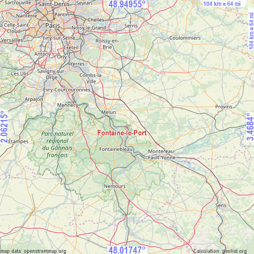
Fontaine-le-Port GPS coordinates[2]
48° 29' 8.34" North, 2° 45' 55.008" East
| Map corner | latitude | longitude |
|---|---|---|
| Upper-left | 48.94955°, | 2.06215° |
| Center: | 48.48565°, | 2.76528° |
| Lower-right: | 48.01747°, | 3.4684° |
| Map W x H: | 103.6×103.6 km | = 64.4×64.4mi |
| max Lat: | 51.07786° ⇑32% North |
| Fontaine-le-Port: | 48.48565° |
| min Lat: | ⇓68% South 41.3874° |
| min Long | Fontaine-le-Por | max Long |
| -5.08615° | 2.76528° | 9.52242° |
| W 54.4%⇐ | ⇒45.6% E |
Elevation
Elevation of Fontaine-le-Port is 83 m = 272 ft, and this is 110.7 m = 363 ft below average elevation for this country.
| Max E: |
2333 m = 7654 ft | 67.8% |
| Avg. | 193.7 m = 635 ft | |
| Fontaine-le-Port | 83 m = 272 ft | |
Min E: |
-1 m = -3 ft | 32.2% |
See also: France elevation on elevation.city.
Geographical zone
Fontaine-le-Port is located in North temperate zone (between Tropic of Cancer and the Arctic Circle). Distance of this North polar circle is 2010.1 km =1249 mi to North.| Distance of | km | miles | from Fontaine-le-Port |
|---|---|---|---|
| North Pole | 4616 | 2868.2 | to North |
| Arctic Circle | 2010.1 | 1249 | to North |
| Tropic Cancer | 2785.2 | 1730.6 | to South |
| Equator | 5391.1 | 3349.9 | to South |


Nearby cities:
15 places around Fontaine-le-Port: (largest is in red/bold)
• Bois-le-Roi
4.7 km =2.9 mi,  253°
253°
• Chartrettes
4.8 km =3 mi,  273°
273°
• Féricy
3.8 km =2.4 mi,  137°
137°
• Héricy
4.1 km =2.5 mi,  180°
180°
• La Rochette
7.9 km =4.9 mi,  288°
288°
• Le Châtelet-en-Brie
3.1 km =1.9 mi,  39°
39°
• Les Écrennes
7.2 km =4.5 mi,  72°
72°
• Livry-sur-Seine
7.3 km =4.5 mi,  299°
299°
• Machault
5.9 km =3.7 mi,  124°
124°
• Pamfou
8.2 km =5.1 mi,  109°
109°
• Samois-sur-Seine
3.8 km =2.4 mi,  196°
196°
• Samoreau
6.3 km =3.9 mi,  186°
186°
• Sivry-Courtry
4.8 km =3 mi,  350°
350°
• Vaux-le-Pénil
7.2 km =4.5 mi,  310°
310°
• Vulaines-sur-Seine
6 km =3.7 mi, 180°
Sources, notices
• [Note1] Compared only with cities in France existing in our database
• [Src1] Map data: © OpenStreetMap contributors (CC-BY-SA)
• [Src2] Other city data from geonames.org with taken over terms of usage.
• [Src3] Geographical zone / Annual Mean Temperature by Robert A. Rohde @ Wikipedia
